Virgin Islands
Central America and the CaribbeanVQ September 03, 2025
Background
The Danes secured control over the southern Virgin Islands of Saint Thomas, Saint John, and Saint Croix during the 17th and early 18th centuries. Sugarcane, produced by African slave labor, drove the islands' economy during the 18th and early 19th centuries. In 1917, the US purchased the Danish holdings, which had been in economic decline since the abolition of slavery in 1848. In 2017, Hurricane Irma passed over the northern Virgin Islands of Saint Thomas and Saint John and inflicted severe damage to structures, roads, the airport on Saint Thomas, communications, and electricity. Less than two weeks later, Hurricane Maria passed over the island of Saint Croix in the southern Virgin Islands, inflicting considerable damage with heavy winds and flooding rains.
Geographic coordinates
18 20 N, 64 50 W
Natural hazards
several hurricanes in recent years; frequent and severe droughts and floods; occasional earthquakes
Area - comparative
twice the size of Washington, D.C.
Environmental issues
lack of natural freshwater resources; protection of coral reefs; solid waste management; coastal development; increased boating and overfishing
Climate
subtropical, tempered by easterly trade winds, relatively low humidity, little seasonal temperature variation; rainy season September to November
Coastline
188 km
Land boundaries
Total: 0 km
Land use
Agricultural land: 9.4% (2022 est.)
Arable land: 2.6% (2022 est.)
Permanent crops: 0.6% (2022 est.)
Permanent pasture: 6.3% (2022 est.)
Forest: 57.7% (2022 est.)
Other: 32.8% (2022 est.)
Arable land: 2.6% (2022 est.)
Permanent crops: 0.6% (2022 est.)
Permanent pasture: 6.3% (2022 est.)
Forest: 57.7% (2022 est.)
Other: 32.8% (2022 est.)
Maritime claims
Territorial sea: 12 nm
Exclusive economic zone: 200 nm
Exclusive economic zone: 200 nm
Natural resources
pleasant climate, beaches foster tourism
Geography - note
important location along the Anegada Passage, a key shipping lane for the Panama Canal; Saint Thomas has one of the best natural deepwater harbors in the Caribbean
Terrain
mostly hilly to rugged and mountainous with little flat land
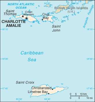
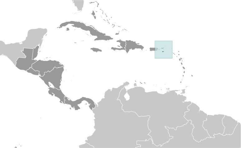
Location
Caribbean, islands between the Caribbean Sea and the North Atlantic Ocean, east of Puerto Rico
Map references
Central America and the Caribbean
Irrigated land
1 sq km (2012)
Population distribution
overall population density throughout the islands is relatively low, but concentrations appear around Charlotte Amalie on St. Thomas and Christiansted on St. Croix
Elevation
Highest point: Crown Mountain 474 m
Lowest point: Caribbean Sea 0 m
Lowest point: Caribbean Sea 0 m
Area
Total : 1,910 sq km
Land: 346 sq km
Water: 1,564 sq km
Land: 346 sq km
Water: 1,564 sq km
Age structure
0-14 years: 18.7% (male 9,983/female 9,547)
15-64 years: 59.8% (male 29,519/female 32,899)
65 years and over: 21.5% (2024 est.) (male 10,018/female 12,411)
15-64 years: 59.8% (male 29,519/female 32,899)
65 years and over: 21.5% (2024 est.) (male 10,018/female 12,411)
Sex ratio
At birth: 1.06 male(s)/female
0-14 years: 1.05 male(s)/female
15-64 years: 0.9 male(s)/female
65 years and over: 0.81 male(s)/female
Total population: 0.9 male(s)/female (2024 est.)
0-14 years: 1.05 male(s)/female
15-64 years: 0.9 male(s)/female
65 years and over: 0.81 male(s)/female
Total population: 0.9 male(s)/female (2024 est.)
Nationality
Noun: Virgin Islander(s) (US citizens)
Adjective: Virgin Islander
Adjective: Virgin Islander
Urbanization
Urban population: 96.2% of total population (2023)
Rate of urbanization: -0.11% annual rate of change (2020-25 est.)
Rate of urbanization: -0.11% annual rate of change (2020-25 est.)
Major urban areas - population
52,000 CHARLOTTE AMALIE (capital) (2018)
Dependency ratios
Total dependency ratio: 67.2 (2024 est.)
Youth dependency ratio: 31.3 (2024 est.)
Elderly dependency ratio: 35.9 (2024 est.)
Potential support ratio: 2.8 (2024 est.)
Youth dependency ratio: 31.3 (2024 est.)
Elderly dependency ratio: 35.9 (2024 est.)
Potential support ratio: 2.8 (2024 est.)
Sanitation facility access
Improved:
Total: 99.1% of population (2022 est.)
Unimproved:
Total: 0.9% of population (2022 est.)
Total: 99.1% of population (2022 est.)
Unimproved:
Total: 0.9% of population (2022 est.)
Ethnic groups
African-American or African descent 71.4%, White 13.3%, Indigenous 0.4%, Native Hawaiian and other Pacific Islander 0.1%, other 6.3%, mixed 7.5% (2020 est.)
Note: 18.4% self-identify as Latino
Note: 18.4% self-identify as Latino
Religions
Protestant 65.5%, Roman Catholic 27.1%, other Christians 2.2%, other 1.5%, none 3.7% (2010 est.)
Languages
English 71.6%, Spanish or Spanish Creole 17.2%, French or French Creole 8.6%, other 2.5% (2010 est.)
Gross reproduction rate
0.95 (2024 est.)
Currently married women (ages 15-49)
27.4% (2023)
Youth unemployment rate (ages 15-24)
Total: 25.3% (2024 est.)
Male: 22% (2024 est.)
Female: 28.9% (2024 est.)
note: % of labor force ages 15-24 seeking employment
Male: 22% (2024 est.)
Female: 28.9% (2024 est.)
note: % of labor force ages 15-24 seeking employment
Net migration rate
-7.3 migrant(s)/1,000 population (2024 est.)
Median age
Total: 43 years (2024 est.)
Male: 42.1 years
Female: 43.9 years
Male: 42.1 years
Female: 43.9 years
Total fertility rate
1.97 children born/woman (2024 est.)
Population
Total: 104,377 (2024 est.)
Male: 49,520
Female: 54,857
Male: 49,520
Female: 54,857
Infant mortality rate
Total: 7.3 deaths/1,000 live births (2024 est.)
Male: 8.3 deaths/1,000 live births
Female: 6.3 deaths/1,000 live births
Male: 8.3 deaths/1,000 live births
Female: 6.3 deaths/1,000 live births
Death rate
9.2 deaths/1,000 population (2024 est.)
Birth rate
11.1 births/1,000 population (2024 est.)
Life expectancy at birth
Total population: 80.7 years (2024 est.)
Male: 77.6 years
Female: 84.1 years
Male: 77.6 years
Female: 84.1 years
Population growth rate
-0.54% (2024 est.)
Waste and recycling
Municipal solid waste generated annually: 146,500 tons (2024 est.)
Carbon dioxide emissions
2.378 million metric tonnes of CO2 (2023 est.)
From petroleum and other liquids: 2.378 million metric tonnes of CO2 (2023 est.)
From petroleum and other liquids: 2.378 million metric tonnes of CO2 (2023 est.)
Diplomatic representation from the US
none (territory of the US)
Administrative divisions
none (territory of the US); there are no first-order administrative divisions as defined by the US government, but 3 islands are considered second-order: Saint Croix, Saint John, Saint Thomas
Capital
Name: Charlotte Amalie
Geographic coordinates: 18 21 N, 64 56 W
Time difference: UTC-4 (1 hour ahead of Washington, DC, during Standard Time)
Etymology: Named in honor of Danish King CHRISTIAN V’s wife, Charlotte AMALIE of Hesse-Kassel, after the colony was established in 1672
Geographic coordinates: 18 21 N, 64 56 W
Time difference: UTC-4 (1 hour ahead of Washington, DC, during Standard Time)
Etymology: Named in honor of Danish King CHRISTIAN V’s wife, Charlotte AMALIE of Hesse-Kassel, after the colony was established in 1672
Constitution
History: 22 July 1954 - the Revised Organic Act of the Virgin Islands functions as a constitution for this US territory
Executive branch
Chief of state: President Donald J. TRUMP (since 20 January 2025)
Head of government: Governor Albert BRYAN, Jr. (since 7 January 2019)
Cabinet: Territorial Cabinet appointed by the governor and confirmed by the Senate
Election/appointment process: President and vice president indirectly elected on the same ballot by an Electoral College of electors chosen from each state; president and vice president serve a 4-year term (eligible for a second term); under the US Constitution, residents of the Virgin Islands do not vote in elections for US president and vice president, but they can vote in the Democratic and Republican party presidential primary elections; governor and lieutenant governor directly elected on the same ballot by absolute majority vote in 2 rounds if needed for a 4-year term (eligible for a second term)
Most recent election date: 8 November 2022
Election results:
2022: Albert BRYAN, Jr. reelected governor; percent of vote - Albert BRYAN, Jr. (Democratic Party) 56%, Kurt VIALET (independent) 38%
2018: Albert BRYAN, Jr. elected governor in the second round; percent of vote in first round - Albert BRYAN, Jr. (Democratic Party) 38.1%, Kenneth MAPP (independent) 33.5%, Adlah "Foncie" DONASTORG, Jr. (independent) 16.5%, other 11.9%; percent of vote in second round- Albert BRYAN, Jr. (Democratic Party) 54.5%, Kenneth MAPP (independent) 45.2%, other 0.3%
Expected date of next election: November 2026
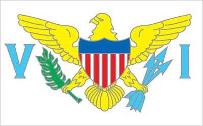
Flag
Description: White field with a modified US coat of arms in the center between the large blue initials "V" and "I"; the coat of arms shows a yellow eagle holding an olive branch in its right talon and three arrows in its left, with a shield of seven red and six white vertical stripes below a blue panel
Meaning: White is a symbol of purity, and the letters stand for the Virgin Islands
Meaning: White is a symbol of purity, and the letters stand for the Virgin Islands
Independence
none (territory of the US)
Judicial branch
Highest court(s): Supreme Court of the Virgin Islands (consists of the chief justice and 2 associate justices)
Judge selection and term of office: Justices appointed by the governor and confirmed by the Virgin Islands Senate; justices serve initial 10-year terms and upon reconfirmation, during the extent of good behavior; chief justice elected to position by peers for a 3-year term
Subordinate courts: Superior Court (Territorial Court renamed in 2004); US Court of Appeals for the Third Circuit (has appellate jurisdiction over the District Court of the Virgin Islands; it is a territorial court and is not associated with a US federal judicial district); District Court of the Virgin Islands
Legal system
US common law
Legislative branch
Note: The Virgin Islands delegate to the US House of Representatives can vote when serving on a committee and when the House meets as the Committee of the Whole House, but not when legislation is submitted for a “full floor” House vote
International organization participation
AOSIS (observer), Interpol (subbureau), IOC, UPU, WFTU (NGOs)
National holiday
Transfer Day (from Denmark to the US), 31 March (1917)
Political parties
Democratic Party
Independent Citizens' Movement or ICM
Republican Party
Independent Citizens' Movement or ICM
Republican Party
Suffrage
18 years of age; universal
Note: island residents are US citizens but do not vote in US presidential elections
Note: island residents are US citizens but do not vote in US presidential elections
Government type
unincorporated organized territory of the US with local self-government; republican form of territorial government with separate executive, legislative, and judicial branches
Country name
Conventional long form: None
Conventional short form: Virgin Islands
Former: Danish West Indies
Abbreviation: VI
Etymology: In 1493, the islets, cays, and rocks around the major islands in the chain reminded explorer Christopher COLUMBUS of Saint Ursula and her 11,000 virgin followers (Santa Ursula y las Once Mil Virgenes), which over time was shortened to the Virgins (las Virgenes)
Diplomatic representation in the US
none (territory of the US)
National anthem(s)
Title: "Virgin Islands March"
Lyrics/music: Multiple/Alton Augustus ADAMS, Sr.
History: Adopted 1963; serves as a local anthem
_____
Title: "The Star-Spangled Banner"
Lyrics/music: Francis Scott KEY/John Stafford SMITH
History: Official anthem, as a US territory
Lyrics/music: Multiple/Alton Augustus ADAMS, Sr.
History: Adopted 1963; serves as a local anthem
_____
Title: "The Star-Spangled Banner"
Lyrics/music: Francis Scott KEY/John Stafford SMITH
History: Official anthem, as a US territory
Citizenship
see United States
Exports - commodities
refined petroleum, jewelry, recreational boats, watches, rum (2019)
Top five export commodities based on value in dollars
Top five export commodities based on value in dollars
Agricultural products
fruit, vegetables, sorghum; Senepol cattle
Budget
Revenues: $1.496 billion (2016 est.)
Expenditures: $1.518 billion (2016 est.)
Expenditures: $1.518 billion (2016 est.)
Imports - commodities
refined petroleum, crude petroleum, rubber piping, jewelry, beer (2019)
Exchange rates
the US dollar is used
Industries
tourism, watch assembly, rum distilling, construction, pharmaceuticals, electronics
Economic overview
high-income, tourism-based American territorial economy; severe COVID-19 economic disruptions; major rum distillery; high public debt; sluggish reopening of large oil refinery; environmentally susceptible to hurricanes; many informal industries
GDP (official exchange rate)
$4.672 billion (2022 est.)
note: data in current dollars at official exchange rate
note: data in current dollars at official exchange rate
GDP - composition, by end use
Household consumption: 68.9% (2022 est.)
Government consumption: 34.4% (2022 est.)
Investment in fixed capital: 7.5% (2016 est.)
Investment in inventories: 15% (2016 est.)
Exports of goods and services: 97.4% (2022 est.)
Imports of goods and services: -108.3% (2022 est.)
Note: Figures may not total 100% due to rounding or gaps in data collection
Imports - partners
India 18%, Algeria 14%, South Korea 9%, Argentina 9%, Sweden 7%, Brazil 5% (2019)
Exports - partners
Haiti 14%, Guadeloupe 7%, Malaysia 7%, Martinique 7%, Barbados 7%, British Virgin Islands 5% (2019)
Labor force
47,200 (2024 est.)
note: number of people ages 15 or older who are employed or seeking work
note: number of people ages 15 or older who are employed or seeking work
Unemployment rate
12.1% (2024 est.)
12.4% (2023 est.)
13.1% (2022 est.)
note: % of labor force seeking employment
12.4% (2023 est.)
13.1% (2022 est.)
note: % of labor force seeking employment
Real GDP (purchasing power parity)
$4.9 billion (2022 est.)
$4.965 billion (2021 est.)
$4.789 billion (2020 est.)
note: data in 2021 dollars
$4.965 billion (2021 est.)
$4.789 billion (2020 est.)
note: data in 2021 dollars
Real GDP per capita
$46,500 (2022 est.)
$46,900 (2021 est.)
$45,100 (2020 est.)
note: data in 2021 dollars
$46,900 (2021 est.)
$45,100 (2020 est.)
note: data in 2021 dollars
Imports
$5.058 billion (2022 est.)
$4.057 billion (2021 est.)
$3.184 billion (2020 est.)
Note: GDP expenditure basis - imports of goods and services in current dollars
$4.057 billion (2021 est.)
$3.184 billion (2020 est.)
Note: GDP expenditure basis - imports of goods and services in current dollars
Exports
$4.549 billion (2022 est.)
$4.069 billion (2021 est.)
$1.62 billion (2020 est.)
Note: GDP expenditure basis - exports of goods and services in current dollars
$4.069 billion (2021 est.)
$1.62 billion (2020 est.)
Note: GDP expenditure basis - exports of goods and services in current dollars
Real GDP growth rate
-1.3% (2022 est.)
3.7% (2021 est.)
-1.6% (2020 est.)
note: annual GDP % growth based on constant local currency
3.7% (2021 est.)
-1.6% (2020 est.)
note: annual GDP % growth based on constant local currency
Electricity access
Electrification - total population: 100% (2022 est.)
Electricity generation sources
Fossil fuels: 97.2% of total installed capacity (2023 est.)
Solar: 2.8% of total installed capacity (2023 est.)
Solar: 2.8% of total installed capacity (2023 est.)
Petroleum
Refined petroleum consumption: 16,000 bbl/day (2023 est.)
Coal
Exports: 4 metric tons (2023 est.)
Electricity
Installed generating capacity: 326,000 kW (2023 est.)
Consumption: 618.819 million kWh (2023 est.)
Transmission/distribution losses: 50.181 million kWh (2023 est.)
Consumption: 618.819 million kWh (2023 est.)
Transmission/distribution losses: 50.181 million kWh (2023 est.)
Internet users
Percent of population: 64% (2017 est.)
Internet country code
.vi
Broadcast media
about a dozen TV stations, including 1 public TV station; multi-channel cable and satellite TV available; 24 radio stations
Telephones - mobile cellular
Total subscriptions: 80,000 (2021 est.)
Subscriptions per 100 inhabitants: 80 (2021 est.)
Subscriptions per 100 inhabitants: 80 (2021 est.)
Broadband - fixed subscriptions
Total: 9,000 (2022 est.)
Subscriptions per 100 inhabitants: 10 (2022 est.)
Subscriptions per 100 inhabitants: 10 (2022 est.)
Telephones - fixed lines
Total subscriptions: 76,000 (2021 est.)
Subscriptions per 100 inhabitants: 88 (2022 est.)
Subscriptions per 100 inhabitants: 88 (2022 est.)
Airports
2 (2025)
Merchant marine
Total: 2 (2023)
By type: General cargo 1, other 1
By type: General cargo 1, other 1
Heliports
4 (2025)
Military - note
defense is the responsibility of the US
Military and security forces
US Virgin Islands Police Department (VIPD); US Virgin Islands National Guard (VING) (2025)
Dependency status
unincorporated, organized territory of the US, with policy relations with the US federal government under the jurisdiction of the Office of Insular Affairs, US Department of the Interior
Ports
Total ports: 6 (2024)
Large: 0
Medium: 0
Small: 3
Very small: 3
Ports with oil terminals: 3
Key ports: Charlotte Amalie, Christiansted, Cruz Bay, Frederiksted, Limetree Bay, Port Alucroix
Large: 0
Medium: 0
Small: 3
Very small: 3
Ports with oil terminals: 3
Key ports: Charlotte Amalie, Christiansted, Cruz Bay, Frederiksted, Limetree Bay, Port Alucroix
Quick Facts
Also in Central America and the Caribbean
AnguillaAntigua and BarbudaArubaBahamas, TheBarbadosBelizeBritish Virgin IslandsCayman IslandsCosta RicaCuba
View all →