Bahamas, The
Central America and the CaribbeanBF December 30, 2025
Background
Lucayan Indians inhabited the Bahama islands when Christopher COLUMBUS first set foot in the New World in 1492. British settlement of the islands began in 1647; the islands became a colony in 1783. Piracy thrived in the 17th and 18th centuries because of The Bahamas' close proximity to shipping lanes. Since gaining independence from the UK in 1973, The Bahamas has prospered through tourism, international banking, and investment management, which comprise up to 85% of GDP. Because of its proximity to the US -- the nearest Bahamian landmass is only 80 km (50 mi) from Florida -- the country is a major transshipment point for illicit trafficking to the US mainland, as well as to Europe. US law enforcement agencies cooperate closely with The Bahamas; the Drug Enforcement Administration, US Coast Guard, and US Customs and Border Protection assist Bahamian authorities with maritime security and law enforcement through Operation Bahamas, Turks and Caicos, or OPBAT.
Geographic coordinates
24 15 N, 76 00 W
Natural hazards
hurricanes and other tropical storms cause extensive flood and wind damage
Area - comparative
slightly smaller than Connecticut
Environmental issues
coral reef decay; solid waste disposal
International environmental agreements
Party to: Biodiversity, Climate Change, Climate Change-Kyoto Protocol, Climate Change-Paris Agreement, Comprehensive Nuclear Test Ban, Desertification, Endangered Species, Hazardous Wastes, Law of the Sea, Nuclear Test Ban, Ozone Layer Protection, Ship Pollution, Wetlands
Signed, but not ratified: None of the selected agreements
Signed, but not ratified: None of the selected agreements
Climate
tropical marine; moderated by warm waters of Gulf Stream
Coastline
3,542 km
Land boundaries
Total: 0 km
Land use
Agricultural land: 1.3% (2023 est.)
Arable land: 0.8% (2023 est.)
Permanent crops: 0.3% (2023 est.)
Permanent pasture: 0.2% (2023 est.)
Forest: 50.9% (2023 est.)
Other: 47.8% (2023 est.)
Arable land: 0.8% (2023 est.)
Permanent crops: 0.3% (2023 est.)
Permanent pasture: 0.2% (2023 est.)
Forest: 50.9% (2023 est.)
Other: 47.8% (2023 est.)
Maritime claims
Territorial sea: 12 nm
Exclusive economic zone: 200 nm
Exclusive economic zone: 200 nm
Natural resources
salt, aragonite, timber, arable land
Geography - note
strategic location adjacent to US and Cuba; extensive island chain of which 30 are inhabited
Terrain
long, flat coral formations with some low rounded hills
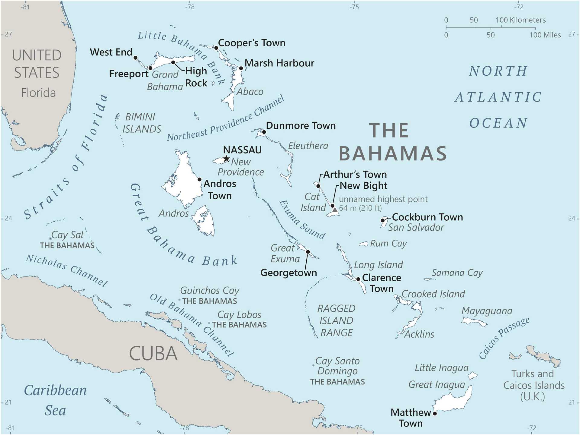
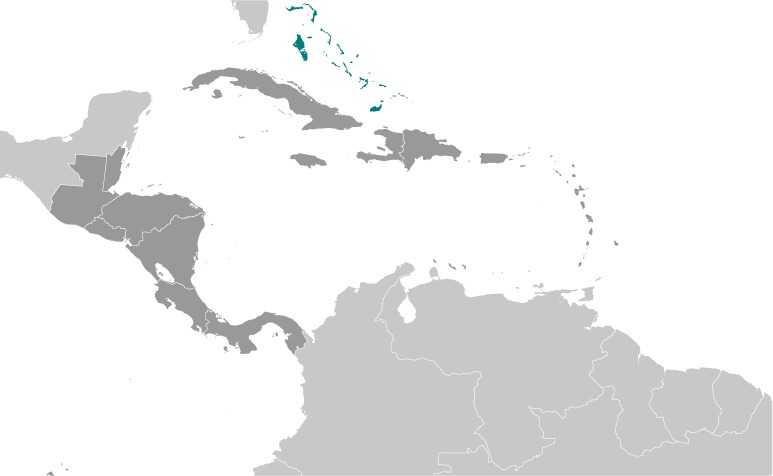
Location
chain of islands in the North Atlantic Ocean, southeast of Florida, northeast of Cuba; note - although The Bahamas does not border the Caribbean Sea, geopolitically it is often designated as a Caribbean nation
Map references
Central America and the Caribbean
Irrigated land
10 sq km (2012)
Total renewable water resources
700 million cubic meters (2022 est.)
Population distribution
most of the population lives in urban areas, with two thirds living on New Providence Island where Nassau is located
Elevation
Highest point: 1.3 km NE of Old Bight on Cat Island 64 m
Lowest point: Atlantic Ocean 0 m
Lowest point: Atlantic Ocean 0 m
Area
Total : 13,880 sq km
Land: 10,010 sq km
Water: 3,870 sq km
Land: 10,010 sq km
Water: 3,870 sq km
Age structure
0-14 years: 21.4% (male 41,675/female 46,363)
15-64 years: 70% (male 132,626/female 154,866)
65 years and over: 8.6% (2024 est.) (male 15,799/female 19,533)
15-64 years: 70% (male 132,626/female 154,866)
65 years and over: 8.6% (2024 est.) (male 15,799/female 19,533)
Sex ratio
At birth: 1.03 male(s)/female
0-14 years: 0.9 male(s)/female
15-64 years: 0.86 male(s)/female
65 years and over: 0.81 male(s)/female
Total population: 0.86 male(s)/female (2024 est.)
0-14 years: 0.9 male(s)/female
15-64 years: 0.86 male(s)/female
65 years and over: 0.81 male(s)/female
Total population: 0.86 male(s)/female (2024 est.)
Nationality
Noun: Bahamian(s)
Adjective: Bahamian
Adjective: Bahamian
Urbanization
Urban population: 83.6% of total population (2023)
Rate of urbanization: 1.02% annual rate of change (2020-25 est.)
Rate of urbanization: 1.02% annual rate of change (2020-25 est.)
Drinking water source
Improved:
Total: 98.9% of population
Total: 98.9% of population
Major urban areas - population
280,000 NASSAU (capital) (2018)
Physician density
1.9 physicians/1,000 population (2017)
Hospital bed density
2.7 beds/1,000 population (2021 est.)
Dependency ratios
Total dependency ratio: 42.9 (2024 est.)
Youth dependency ratio: 30.6 (2024 est.)
Elderly dependency ratio: 12.3 (2024 est.)
Potential support ratio: 8.1 (2024 est.)
Youth dependency ratio: 30.6 (2024 est.)
Elderly dependency ratio: 12.3 (2024 est.)
Potential support ratio: 8.1 (2024 est.)
Ethnic groups
African descent 90.6%, White 4.7%, mixed 2.1%, other 1.9%, unspecified 0.7% (2010 est.)
Note: Data represent population by racial group
Note: Data represent population by racial group
Religions
Protestant 69.9% (includes Baptist 34.9%, Anglican 13.7%, Pentecostal 8.9% Seventh Day Adventist 4.4%, Methodist 3.6%, Church of God 1.9%, Plymouth Brethren 1.6%, other Protestant 0.9%), Roman Catholic 12%, other Christian 13% (includes Jehovah's Witness 1.1%), other 0.6%, none 1.9%, unspecified 2.6% (2010 est.)
Languages
English (official), Creole (among Haitian immigrants)
Health expenditure
7.1% of GDP (2021)
15.8% of national budget (2022 est.)
15.8% of national budget (2022 est.)
Gross reproduction rate
0.71 (2024 est.)
Youth unemployment rate (ages 15-24)
Total: 17.8% (2024 est.)
Male: 17.8% (2024 est.)
Female: 17.8% (2024 est.)
note: % of labor force ages 15-24 seeking employment
Male: 17.8% (2024 est.)
Female: 17.8% (2024 est.)
note: % of labor force ages 15-24 seeking employment
Net migration rate
3.2 migrant(s)/1,000 population (2024 est.)
Median age
Total: 30.7 years (2024 est.)
Male: 30.6 years
Female: 30.7 years
Male: 30.6 years
Female: 30.7 years
Maternal mortality ratio
76 deaths/100,000 live births (2023 est.)
Total fertility rate
1.44 children born/woman (2024 est.)
Population
Total: 410,862 (2024 est.)
Male: 190,100
Female: 220,762
Male: 190,100
Female: 220,762
Infant mortality rate
Total: 9.4 deaths/1,000 live births (2024 est.)
Male: 10.5 deaths/1,000 live births
Female: 8.2 deaths/1,000 live births
Male: 10.5 deaths/1,000 live births
Female: 8.2 deaths/1,000 live births
Tobacco use
Total: 10.8% (2025 est.)
Male: 20.8% (2025 est.)
Female: 1.9% (2025 est.)
Male: 20.8% (2025 est.)
Female: 1.9% (2025 est.)
Obesity - adult prevalence rate
31.6% (2016)
Death rate
5.6 deaths/1,000 population (2024 est.)
Birth rate
13.1 births/1,000 population (2024 est.)
Alcohol consumption per capita
Total: 9.48 liters of pure alcohol (2019 est.)
Beer: 3.66 liters of pure alcohol (2019 est.)
Wine: 1.43 liters of pure alcohol (2019 est.)
Spirits: 4.08 liters of pure alcohol (2019 est.)
Other alcohols: 0.31 liters of pure alcohol (2019 est.)
Beer: 3.66 liters of pure alcohol (2019 est.)
Wine: 1.43 liters of pure alcohol (2019 est.)
Spirits: 4.08 liters of pure alcohol (2019 est.)
Other alcohols: 0.31 liters of pure alcohol (2019 est.)
Life expectancy at birth
Total population: 76.7 years (2024 est.)
Male: 75.1 years
Female: 78.4 years
Male: 75.1 years
Female: 78.4 years
Education expenditure
2.7% of GDP (2023 est.)
10.6% national budget (2025 est.)
10.6% national budget (2025 est.)
Population growth rate
1.07% (2024 est.)
Total water withdrawal
Municipal: 31 million cubic meters (2022 est.)
Waste and recycling
Municipal solid waste generated annually: 264,000 tons (2024 est.)
Percent of municipal solid waste recycled: 24.9% (2022 est.)
Percent of municipal solid waste recycled: 24.9% (2022 est.)
Particulate matter emissions
5.2 micrograms per cubic meter (2019 est.)
Carbon dioxide emissions
2.99 million metric tonnes of CO2 (2023 est.)
From coal and metallurgical coke: 2,000 metric tonnes of CO2 (2023 est.)
From petroleum and other liquids: 2.966 million metric tonnes of CO2 (2023 est.)
From consumed natural gas: 23,000 metric tonnes of CO2 (2023 est.)
From coal and metallurgical coke: 2,000 metric tonnes of CO2 (2023 est.)
From petroleum and other liquids: 2.966 million metric tonnes of CO2 (2023 est.)
From consumed natural gas: 23,000 metric tonnes of CO2 (2023 est.)
Energy consumption per capita
104.409 million Btu/person (2023 est.)
Administrative divisions
31 districts; Acklins Islands, Berry Islands, Bimini, Black Point, Cat Island, Central Abaco, Central Andros, Central Eleuthera, City of Freeport, Crooked Island and Long Cay, East Grand Bahama, Exuma, Grand Cay, Harbour Island, Hope Town, Inagua, Long Island, Mangrove Cay, Mayaguana, Moore's Island, North Abaco, North Andros, North Eleuthera, Ragged Island, Rum Cay, San Salvador, South Abaco, South Andros, South Eleuthera, Spanish Wells, West Grand Bahama
Capital
Name: Nassau
Geographic coordinates: 25 05 N, 77 21 W
Time difference: UTC-5 (same time as Washington, DC, during Standard Time)
Daylight saving time: +1hr, begins second Sunday in March; ends first Sunday in November
Etymology: Named after King WILLIAM III of England (1650-1702), who was a member of the House of Orange-Nassau
Constitution
History: Previous 1964 (pre-independence); latest adopted 20 June 1973, effective 10 July 1973
Amendment process: Proposed as an "Act" by Parliament; passage of amendments to articles such as the organization and composition of the branches of government requires approval by at least two-thirds majority of the membership of both houses of Parliament and majority approval in a referendum; passage of amendments to constitutional articles such as fundamental rights and individual freedoms, the powers, authorities, and procedures of the branches of government, or changes to the Bahamas Independence Act 1973 requires approval by at least three-fourths majority of the membership of both houses and majority approval in a referendum
Amendment process: Proposed as an "Act" by Parliament; passage of amendments to articles such as the organization and composition of the branches of government requires approval by at least two-thirds majority of the membership of both houses of Parliament and majority approval in a referendum; passage of amendments to constitutional articles such as fundamental rights and individual freedoms, the powers, authorities, and procedures of the branches of government, or changes to the Bahamas Independence Act 1973 requires approval by at least three-fourths majority of the membership of both houses and majority approval in a referendum
Executive branch
Chief of state: King CHARLES III (since 8 September 2022); represented by Governor-General Cynthia A. PRATT (since 1 September 2023)
Head of government: Prime Minister Philip Edward DAVIS (since 17 September 2021)
Cabinet: Cabinet appointed by governor-general on recommendation of prime minister
Election/appointment process: The monarchy is hereditary; governor-general appointed by the monarch on the advice of the prime minister; following legislative elections, the governor-general appoints the leader of the majority party or majority coalition as prime minister; the prime minister recommends the deputy prime minister
Flag
Description: Three equal horizontal bands of aquamarine (top), gold, and aquamarine, with a black equilateral triangle based on the left side
Meaning: The band colors represent the islands' golden beaches surrounded by the aquamarine sea; black stands for the vigor and force of a united people, and the triangle for the people's enterprise and determination
Meaning: The band colors represent the islands' golden beaches surrounded by the aquamarine sea; black stands for the vigor and force of a united people, and the triangle for the people's enterprise and determination
Independence
10 July 1973 (from the UK)
Judicial branch
Highest court(s): Court of Appeal (consists of the court president and 6 justices, organized in 3-member panels); Supreme Court (consists of the chief justice and 19 justices)
Judge selection and term of office: Court of Appeal president and Supreme Court chief justice appointed by the governor-general on the advice of the prime minister after consultation with the leader of the opposition party; other Court of Appeal and Supreme Court justices appointed by the governor general upon recommendation of the Judicial and Legal Services Commission, a 5-member body headed by the chief justice; Court of Appeal justices appointed for life with mandatory retirement normally at age 68 but can be extended until age 70; Supreme Court justices appointed for life with mandatory retirement normally at age 65 but can be extended until age 67
Subordinate courts: Industrial Tribunal; Magistrates' Courts; Family Island Administrators (can also serve as magistrates)
Note: The Bahamas is a member of the 15-member Caribbean Community but is not party to the agreement establishing the Caribbean Court of Justice as its highest appellate court; the Judicial Committee of the Privy Council (in London) serves as the final court of appeal for The Bahamas
Legal system
common-law system based on the English model
Legislative branch
Legislature name: Parliament
Legislative structure: Bicameral
Note: Parliament sits for 5 years from the date of the last general election: the government may dissolve the parliament and call elections at any time
Legislative structure: Bicameral
Note: Parliament sits for 5 years from the date of the last general election: the government may dissolve the parliament and call elections at any time
International organization participation
ACP, ACS, AOSIS, C, Caricom, CDB, CELAC, FAO, G-77, IADB, IAEA, IBRD, ICAO, ICC (NGOs), ICRM, IDA, IFAD, IFC, IFRCS, ILO, IMF, IMO, IMSO, Interpol, IOC, IOM, ISO (correspondent), ITSO, ITU, LAES, MIGA, NAM, OAS, OPANAL, OPCW, Petrocaribe, UN, UNCTAD, UNESCO, UNIDO, UNWTO, UPU, WCO, WHO, WIPO, WMO, WTO (observer)
National holiday
Independence Day, 10 July (1973)
Political parties
Coalition of Independents Party or COI
Democratic National Alliance or DNA
Free National Movement or FNM
Progressive Liberal Party or PLP
Democratic National Alliance or DNA
Free National Movement or FNM
Progressive Liberal Party or PLP
Suffrage
18 years of age; universal
Government type
parliamentary democracy under a constitutional monarchy; a Commonwealth realm
Country name
Conventional long form: Commonwealth of The Bahamas
Conventional short form: The Bahamas
Etymology: Name may be derived from the Spanish baha mar, meaning "low sea," which describes the shallow waters of the Bahama Banks; alternatively, it may be a form of the local name Guanahani, which is of unknown origin and meaning
Conventional short form: The Bahamas
Etymology: Name may be derived from the Spanish baha mar, meaning "low sea," which describes the shallow waters of the Bahama Banks; alternatively, it may be a form of the local name Guanahani, which is of unknown origin and meaning
Diplomatic representation in the US
Chief of mission: Ambassador Wendall Kermith JONES (since 19 April 2022)
Chancery: 600 New Hampshire Ave NW, Suite 530, Washington, DC 20037
Telephone: [1] (202) 319-2660
FAX: [1] (202) 319-2668
Email address and website:
Embassy@bahamasembdc.org
https://www.bahamasembdc.org/
Consulate(s) general: Atlanta, Miami, New York
Chancery: 600 New Hampshire Ave NW, Suite 530, Washington, DC 20037
Telephone: [1] (202) 319-2660
FAX: [1] (202) 319-2668
Email address and website:
Embassy@bahamasembdc.org
https://www.bahamasembdc.org/
Consulate(s) general: Atlanta, Miami, New York
National anthem(s)
Title: "March On, Bahamaland!"
Lyrics/music: Timothy GIBSON
History: Adopted 1973
_____
Title: "God Save the King"
Lyrics/music: Unknown
History: Royal anthem, as a Commonwealth country
Lyrics/music: Timothy GIBSON
History: Adopted 1973
_____
Title: "God Save the King"
Lyrics/music: Unknown
History: Royal anthem, as a Commonwealth country
International law organization participation
has not submitted an ICJ jurisdiction declaration; non-party state to the ICCt
National symbol(s)
blue marlin, flamingo, yellow elderflower
Citizenship
Citizenship by birth: No
Citizenship by descent only: At least one parent must be a citizen of The Bahamas
Dual citizenship recognized: No
Residency requirement for naturalization: 6-9 years
Citizenship by descent only: At least one parent must be a citizen of The Bahamas
Dual citizenship recognized: No
Residency requirement for naturalization: 6-9 years
National color(s)
aquamarine, yellow, black
Diplomatic representation from the US
Chief of mission: Ambassador Herschel WALKER (since 9 December 2025)
Embassy: 42 Queen Street, Nassau
Mailing address: 3370 Nassau Place, Washington, DC 20521-3370
Telephone: [1] (242) 322-1181
FAX: [1] (242) 356-7174
Email address and website:
Acsnassau@state.gov
https://bs.usembassy.gov/
Embassy: 42 Queen Street, Nassau
Mailing address: 3370 Nassau Place, Washington, DC 20521-3370
Telephone: [1] (242) 322-1181
FAX: [1] (242) 356-7174
Email address and website:
Acsnassau@state.gov
https://bs.usembassy.gov/
Exports - commodities
refined petroleum, ships, aluminum, shellfish, plastics (2023)
note: top five export commodities based on value in dollars
note: top five export commodities based on value in dollars
Exports - partners
USA 36%, Zimbabwe 16%, Cote d'Ivoire 14%, Germany 8%, Guyana 8% (2023)
note: top five export partners based on percentage share of exports
note: top five export partners based on percentage share of exports
Agricultural products
sugarcane, grapefruits, vegetables, bananas, tomatoes, chicken, tropical fruits, oranges, coconuts, mangoes/guavas (2023)
note: top ten agricultural products based on tonnage
note: top ten agricultural products based on tonnage
Budget
Revenues: $2.855 billion (2023 est.)
Expenditures: $3.389 billion (2023 est.)
note: central government revenues and expenses (excluding grants/extrabudgetary units/social security funds) converted to US dollars at average official exchange rate for year indicated
Expenditures: $3.389 billion (2023 est.)
note: central government revenues and expenses (excluding grants/extrabudgetary units/social security funds) converted to US dollars at average official exchange rate for year indicated
Imports - commodities
refined petroleum, ships, aircraft, cars, crude petroleum (2023)
note: top five import commodities based on value in dollars
note: top five import commodities based on value in dollars
Exchange rates
Bahamian dollars (BSD) per US dollar -
Exchange rates:
1 (2024 est.)
1 (2023 est.)
1 (2022 est.)
1 (2021 est.)
1 (2020 est.)
Exchange rates:
1 (2024 est.)
1 (2023 est.)
1 (2022 est.)
1 (2021 est.)
1 (2020 est.)
Industries
tourism, banking, oil bunkering, maritime industries, transshipment and logistics, salt, aragonite, pharmaceuticals
Economic overview
high-income tourism and financial services economy; major income inequality; strong US bilateral relations; several tax relief programs; targeted investment in agriculture, energy, light manufacturing, and technology industries
GDP (official exchange rate)
$15.833 billion (2024 est.)
note: data in current dollars at official exchange rate
note: data in current dollars at official exchange rate
GDP - composition, by end use
Household consumption: 64.3% (2024 est.)
Government consumption: 12.9% (2024 est.)
Investment in fixed capital: 25.7% (2024 est.)
Investment in inventories: 1.1% (2024 est.)
Exports of goods and services: 37.8% (2024 est.)
Imports of goods and services: -41.5% (2024 est.)
note: figures may not total 100% due to rounding or gaps in data collection
Imports - partners
USA 60%, Germany 13%, China 5%, Japan 3%, Brazil 2% (2023)
note: top five import partners based on percentage share of imports
note: top five import partners based on percentage share of imports
Remittances
0.4% of GDP (2024 est.)
0.4% of GDP (2023 est.)
0.4% of GDP (2022 est.)
Note: personal transfers and compensation between resident and non-resident individuals/households/entities
0.4% of GDP (2023 est.)
0.4% of GDP (2022 est.)
Note: personal transfers and compensation between resident and non-resident individuals/households/entities
Labor force
237,100 (2024 est.)
note: number of people ages 15 or older who are employed or seeking work
note: number of people ages 15 or older who are employed or seeking work
Reserves of foreign exchange and gold
$2.512 billion (2023 est.)
$2.609 billion (2022 est.)
$2.433 billion (2021 est.)
note: holdings of gold (year-end prices)/foreign exchange/special drawing rights in current dollars
$2.609 billion (2022 est.)
$2.433 billion (2021 est.)
note: holdings of gold (year-end prices)/foreign exchange/special drawing rights in current dollars
Public debt
73.7% of GDP (2023 est.)
note: central government debt as a % of GDP
note: central government debt as a % of GDP
Unemployment rate
8.5% (2024 est.)
8.7% (2023 est.)
9.3% (2022 est.)
note: % of labor force seeking employment
8.7% (2023 est.)
9.3% (2022 est.)
note: % of labor force seeking employment
Taxes and other revenues
16.2% (of GDP) (2023 est.)
note: central government tax revenue as a % of GDP
note: central government tax revenue as a % of GDP
Real GDP (purchasing power parity)
$14.544 billion (2024 est.)
$14.069 billion (2023 est.)
$13.653 billion (2022 est.)
note: data in 2021 dollars
$14.069 billion (2023 est.)
$13.653 billion (2022 est.)
note: data in 2021 dollars
Inflation rate (consumer prices)
0.4% (2024 est.)
3.1% (2023 est.)
5.6% (2022 est.)
note: annual % change based on consumer prices
3.1% (2023 est.)
5.6% (2022 est.)
note: annual % change based on consumer prices
Current account balance
-$1.053 billion (2024 est.)
-$1.069 billion (2023 est.)
-$1.233 billion (2022 est.)
note: balance of payments - net trade and primary/secondary income in current dollars
-$1.069 billion (2023 est.)
-$1.233 billion (2022 est.)
note: balance of payments - net trade and primary/secondary income in current dollars
Real GDP per capita
$36,200 (2024 est.)
$35,200 (2023 est.)
$34,300 (2022 est.)
note: data in 2021 dollars
$35,200 (2023 est.)
$34,300 (2022 est.)
note: data in 2021 dollars
Imports
$7.069 billion (2024 est.)
$6.273 billion (2023 est.)
$5.843 billion (2022 est.)
note: balance of payments - imports of goods and services in current dollars
$6.273 billion (2023 est.)
$5.843 billion (2022 est.)
note: balance of payments - imports of goods and services in current dollars
Exports
$6.771 billion (2024 est.)
$6.011 billion (2023 est.)
$5.425 billion (2022 est.)
note: balance of payments - exports of goods and services in current dollars
$6.011 billion (2023 est.)
$5.425 billion (2022 est.)
note: balance of payments - exports of goods and services in current dollars
Real GDP growth rate
3.4% (2024 est.)
3% (2023 est.)
10.9% (2022 est.)
note: annual GDP % growth based on constant local currency
3% (2023 est.)
10.9% (2022 est.)
note: annual GDP % growth based on constant local currency
Industrial production growth rate
12.5% (2024 est.)
note: annual % change in industrial value added based on constant local currency
note: annual % change in industrial value added based on constant local currency
GDP - composition, by sector of origin
Agriculture: 0.5% (2024 est.)
Industry: 9.6% (2024 est.)
Services: 77.2% (2024 est.)
note: figures may not total 100% due to non-allocated consumption not captured in sector-reported data
Industry: 9.6% (2024 est.)
Services: 77.2% (2024 est.)
note: figures may not total 100% due to non-allocated consumption not captured in sector-reported data
Electricity access
Electrification - total population: 100% (2022 est.)
Coal
Imports: 600 metric tons (2023 est.)
Electricity generation sources
Fossil fuels: 99.1% of total installed capacity (2023 est.)
Solar: 0.9% of total installed capacity (2023 est.)
Solar: 0.9% of total installed capacity (2023 est.)
Natural gas
Consumption: 14.13 million cubic meters (2023 est.)
Imports: 14.13 million cubic meters (2023 est.)
Imports: 14.13 million cubic meters (2023 est.)
Petroleum
Refined petroleum consumption: 20,000 bbl/day (2023 est.)
Electricity
Installed generating capacity: 608,000 kW (2023 est.)
Consumption: 2.036 billion kWh (2023 est.)
Transmission/distribution losses: 10 million kWh (2023 est.)
Consumption: 2.036 billion kWh (2023 est.)
Transmission/distribution losses: 10 million kWh (2023 est.)
Internet users
Percent of population: 95% (2023 est.)
Internet country code
.bs
Broadcast media
4 major TV providers; 1 TV station is operated by government-owned, commercially run Broadcasting Corporation of the Bahamas (BCB) and competes with 4 privately owned TV stations; multi-channel cable TV subscription service is widely available; 32 licensed broadcast (radio) service providers, with 31 privately owned FM radio stations; the BCB operates a multi-channel radio network with national coverage; the sector is regulated by the Utilities Regulation and Competition Authority (2019)
Telephones - mobile cellular
Total subscriptions: 400,000 (2023 est.)
Subscriptions per 100 inhabitants: 99 (2022 est.)
Subscriptions per 100 inhabitants: 99 (2022 est.)
Broadband - fixed subscriptions
Total: 95,000 (2023 est.)
Subscriptions per 100 inhabitants: 24 (2023 est.)
Subscriptions per 100 inhabitants: 24 (2023 est.)
Telephones - fixed lines
Total subscriptions: 97,000 (2023 est.)
Subscriptions per 100 inhabitants: 24 (2023 est.)
Subscriptions per 100 inhabitants: 24 (2023 est.)
Civil aircraft registration country code prefix
C6
Airports
54 (2025)
Merchant marine
Total: 1,274 (2023)
By type: Bulk carrier 345, container ship 39, general cargo 58, oil tanker 193, other 639
By type: Bulk carrier 345, container ship 39, general cargo 58, oil tanker 193, other 639
Heliports
9 (2025)
Military service age and obligation
18-30 years of age for voluntary service for men and women (18-60 for Reserves); no conscription (2025)
Military and security forces
Royal Bahamas Defense Force (RBDF): includes land, air, maritime elements; Royal Bahamas Police Force (RBPF) (2025)
Note: The RBPF maintains internal security; both the RBDF and the RBPF, as well as the Department of Corrections, report to the Minister of National Security
Note: The RBPF maintains internal security; both the RBDF and the RBPF, as well as the Department of Corrections, report to the Minister of National Security
Military expenditures
0.7% of GDP (2024 est.)
0.8% of GDP (2023 est.)
0.8% of GDP (2022 est.)
0.9% of GDP (2021 est.)
0.9% of GDP (2020 est.)
0.8% of GDP (2023 est.)
0.8% of GDP (2022 est.)
0.9% of GDP (2021 est.)
0.9% of GDP (2020 est.)
Military equipment inventories and acquisitions
most of the RBDF's major equipment inventory has been acquired from the Netherlands or the US (2025)
Military - note
the RBDF was established in 1980; its primary responsibilities are maritime security and safeguarding the territorial integrity of the Bahamas, providing disaster relief and humanitarian assistance, and supporting internal law and order in cooperation with other law enforcement agencies; the RBDF is a naval force with a few light aircraft, coastal patrol craft, and patrol boats, as well as a lightly-armed marine infantry/commando squadron for base and internal security; the RBDF has training relationships with the UK and the US (2025)
Military and security service personnel strengths
approximately 1,500-1,800 active RBDF (2025)
Illicit drugs
USG identification:
Major illicit drug-producing and/or drug-transit country (2025)
Major illicit drug-producing and/or drug-transit country (2025)
Refugees and internally displaced persons
Refugees: 30 (2024 est.)
IDPs: 30 (2024 est.)
IDPs: 30 (2024 est.)
Ports
Total ports: 6 (2024)
Large: 0
Medium: 1
Small: 1
Very small: 4
Ports with oil terminals: 4
Key ports: Clifton Pier, Cockburn Town, Freeport, Matthew Town, Nassau, South Riding Point
Large: 0
Medium: 1
Small: 1
Very small: 4
Ports with oil terminals: 4
Key ports: Clifton Pier, Cockburn Town, Freeport, Matthew Town, Nassau, South Riding Point
Legislative branch - lower chamber
Chamber name: House of Assembly
Number of seats: 39 (all directly elected)
Electoral system: Plurality/majority
Scope of elections: Full renewal
Term in office: 5 years
Most recent election date: 9/16/2021
Parties elected and seats per party: Progressive Liberal Party (PLP) (32); Free National Movement (FNM) (7)
Percentage of women in chamber: 17.9%
Expected date of next election: September 2026
Legislative branch - upper chamber
Chamber name: Senate
Number of seats: 16 (all appointed)
Scope of elections: Full renewal
Term in office: 5 years
Most recent election date: 10/6/2021
Percentage of women in chamber: 31.3%
Expected date of next election: October 2026
Number of seats: 16 (all appointed)
Scope of elections: Full renewal
Term in office: 5 years
Most recent election date: 10/6/2021
Percentage of women in chamber: 31.3%
Expected date of next election: October 2026
National coat of arms
the motto on the Bahamas coat of arms is “Forward, Upward, Onward Together;” the flamingo and marlin supporting the shield are national animals that represent respectively the land and sea; the pink conch shell symbolizes the marine life of the islands, and the green palm fronds represent the natural vegetation; the Santa Maria, Christopher Columbus’s flagship, also appears; the sun signifies the world-famous climate and the bright future of the islands
Quick Facts
Also in Central America and the Caribbean
AnguillaAntigua and BarbudaArubaBarbadosBelizeBritish Virgin IslandsCayman IslandsCosta RicaCubaCuracao
View all →