
Saint Lucia
Central America and the CaribbeanST January 05, 2026
Background
England and France contested Saint Lucia -- with its fine natural harbor at Castries and burgeoning sugar industry -- throughout the 17th and early 18th centuries, with possession changing 14 times; it was finally ceded to the UK in 1814 and became part of the British Windward Islands colony. Even after the abolition of slavery on its plantations in 1834, Saint Lucia remained an agricultural island, dedicated to producing tropical commodity crops. In the mid-20th century, Saint Lucia joined the West Indies Federation (1958–1962) and in 1967 became one of the six members of the West Indies Associated States, with internal self-government. In 1979, Saint Lucia gained full independence.
Geographic coordinates
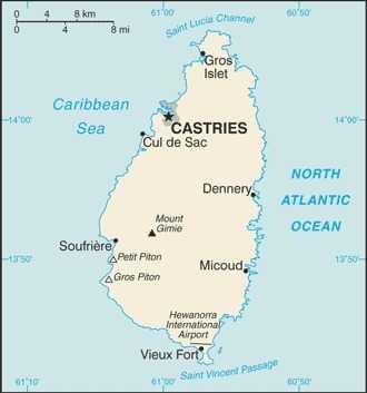
13 53 N, 60 58 W
Natural hazards
hurricanes
Volcanism: Mount Gimie (948 m), also known as Qualibou, is a caldera on the west of the island; the iconic twin pyramidal peaks of Gros Piton (771 m) and Petit Piton (743 m) are lava-dome remnants associated with the Soufrière volcano; there have been no historical magmatic eruptions, but a minor steam eruption in 1766 spread a thin layer of ash over a wide area; Saint Lucia is part of the volcanic-island arc of the Lesser Antilles that extends from Saba in the north to Grenada in the south
Volcanism: Mount Gimie (948 m), also known as Qualibou, is a caldera on the west of the island; the iconic twin pyramidal peaks of Gros Piton (771 m) and Petit Piton (743 m) are lava-dome remnants associated with the Soufrière volcano; there have been no historical magmatic eruptions, but a minor steam eruption in 1766 spread a thin layer of ash over a wide area; Saint Lucia is part of the volcanic-island arc of the Lesser Antilles that extends from Saba in the north to Grenada in the south
Area - comparative
3.5 times the size of Washington, D.C.
Environmental issues
deforestation; soil erosion, particularly in the northern region
International environmental agreements
Party to: Biodiversity, Climate Change, Climate Change-Kyoto Protocol, Climate Change-Paris Agreement, Comprehensive Nuclear Test Ban, Desertification, Endangered Species, Environmental Modification, Hazardous Wastes, Law of the Sea, Marine Dumping-London Convention, Ozone Layer Protection, Ship Pollution, Wetlands, Whaling
Signed, but not ratified: None of the selected agreements
Signed, but not ratified: None of the selected agreements
Climate
tropical, moderated by northeast trade winds; dry season January to April, rainy season May to August
Coastline
158 km
Land boundaries
Total: 0 km
Land use
Agricultural land: 16.3% (2023 est.)
Arable land: 4.4% (2023 est.)
Permanent crops: 11.3% (2023 est.)
Permanent pasture: 0.6% (2023 est.)
Forest: 53.7% (2023 est.)
Other: 30% (2023 est.)
Arable land: 4.4% (2023 est.)
Permanent crops: 11.3% (2023 est.)
Permanent pasture: 0.6% (2023 est.)
Forest: 53.7% (2023 est.)
Other: 30% (2023 est.)
Maritime claims
Territorial sea: 12 nm
Contiguous zone: 24 nm
Exclusive economic zone: 200 nm
Continental shelf: 200 nm or to the edge of the continental margin
Contiguous zone: 24 nm
Exclusive economic zone: 200 nm
Continental shelf: 200 nm or to the edge of the continental margin
Natural resources
forests, sandy beaches, minerals (pumice), mineral springs, geothermal potential
Geography - note
the twin Pitons (Gros Piton and Petit Piton), striking cone-shaped peaks south of Soufrière, are one of the scenic natural highlights of the Caribbean
Terrain
volcanic and mountainous with broad, fertile valleys
Location
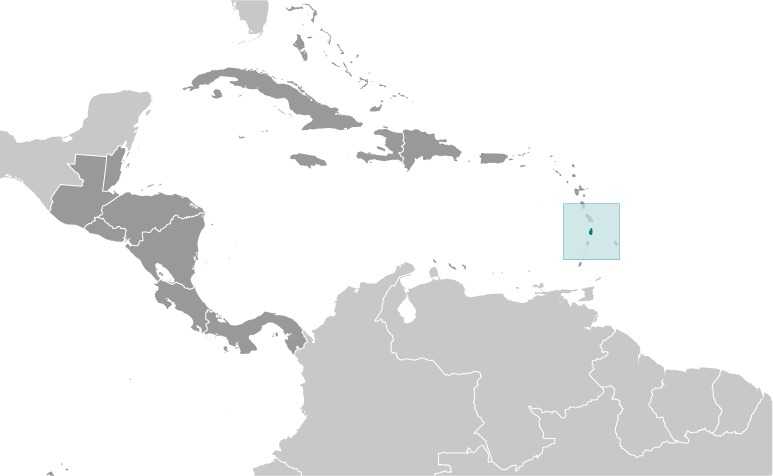
Caribbean, island between the Caribbean Sea and North Atlantic Ocean, north of Trinidad and Tobago
Map references
Central America and the Caribbean
Irrigated land
30 sq km (2012)
Population distribution
most of the population is found on the periphery of the island, with a larger concentration in the north around the capital of Castries
Elevation
Highest point: Mount Gimie 948 m
Lowest point: Caribbean Sea 0 m
Lowest point: Caribbean Sea 0 m
Total renewable water resources
300 million cubic meters (2022 est.)
Area
Total : 616 sq km
Land: 606 sq km
Water: 10 sq km
Land: 606 sq km
Water: 10 sq km
Age structure
0-14 years: 17.9% (male 15,505/female 14,607)
15-64 years: 66.7% (male 54,260/female 57,747)
65 years and over: 15.4% (2024 est.) (male 11,752/female 14,167)
15-64 years: 66.7% (male 54,260/female 57,747)
65 years and over: 15.4% (2024 est.) (male 11,752/female 14,167)
Sex ratio
At birth: 1.06 male(s)/female
0-14 years: 1.06 male(s)/female
15-64 years: 0.94 male(s)/female
65 years and over: 0.83 male(s)/female
Total population: 0.94 male(s)/female (2024 est.)
0-14 years: 1.06 male(s)/female
15-64 years: 0.94 male(s)/female
65 years and over: 0.83 male(s)/female
Total population: 0.94 male(s)/female (2024 est.)
Nationality
Noun: Saint Lucian(s)
Adjective: Saint Lucian
Adjective: Saint Lucian
Urbanization
Urban population: 19.2% of total population (2023)
Rate of urbanization: 0.98% annual rate of change (2020-25 est.)
Rate of urbanization: 0.98% annual rate of change (2020-25 est.)
Drinking water source
Improved:
Urban: 97.2% of population (2022 est.)
Rural: 96.8% of population (2022 est.)
Total: 96.9% of population (2022 est.)
Unimproved:
Urban: 2.8% of population (2022 est.)
Rural: 3.2% of population (2022 est.)
Total: 3.1% of population (2022 est.)
Urban: 97.2% of population (2022 est.)
Rural: 96.8% of population (2022 est.)
Total: 96.9% of population (2022 est.)
Unimproved:
Urban: 2.8% of population (2022 est.)
Rural: 3.2% of population (2022 est.)
Total: 3.1% of population (2022 est.)
Major urban areas - population
22,000 CASTRIES (capital) (2018)
Physician density
4.23 physicians/1,000 population (2020)
Hospital bed density
2 beds/1,000 population (2021 est.)
Dependency ratios
Total dependency ratio: 50 (2024 est.)
Youth dependency ratio: 26.9 (2024 est.)
Elderly dependency ratio: 23.1 (2024 est.)
Potential support ratio: 4.3 (2024 est.)
Youth dependency ratio: 26.9 (2024 est.)
Elderly dependency ratio: 23.1 (2024 est.)
Potential support ratio: 4.3 (2024 est.)
Sanitation facility access
Improved:
Urban: 97.6% of population (2022 est.)
Rural: 92.9% of population (2022 est.)
Total: 93.8% of population (2022 est.)
Unimproved:
Urban: 2.4% of population (2022 est.)
Rural: 7.1% of population (2022 est.)
Total: 6.2% of population (2022 est.)
Urban: 97.6% of population (2022 est.)
Rural: 92.9% of population (2022 est.)
Total: 93.8% of population (2022 est.)
Unimproved:
Urban: 2.4% of population (2022 est.)
Rural: 7.1% of population (2022 est.)
Total: 6.2% of population (2022 est.)
Ethnic groups
Black/African descent 85.3%, mixed 10.9%, East Indian 2.2%, other 1.6%, unspecified 0.1% (2010 est.)
Religions
Roman Catholic 61.5%, Protestant 25.5% (includes Seventh Day Adventist 10.4%, Pentecostal 8.9%, Baptist 2.2%, Anglican 1.6%, Church of God 1.5%, other Protestant 0.9%), other Christian 3.4% (includes Evangelical 2.3% and Jehovah's Witness 1.1%), Rastafarian 1.9%, other 0.4%, none 5.9%, unspecified 1.4% (2010 est.)
Languages
English (official), Saint Lucian Creole
School life expectancy (primary to tertiary education)
Total: 13 years (2023 est.)
Male: 12 years (2023 est.)
Female: 13 years (2023 est.)
Male: 12 years (2023 est.)
Female: 13 years (2023 est.)
Health expenditure
6.2% of GDP (2021)
9% of national budget (2022 est.)
9% of national budget (2022 est.)
Youth unemployment rate (ages 15-24)
Total: 29% (2024 est.)
Male: 31.4% (2024 est.)
Female: 26.3% (2024 est.)
note: % of labor force ages 15-24 seeking employment
Male: 31.4% (2024 est.)
Female: 26.3% (2024 est.)
note: % of labor force ages 15-24 seeking employment
Maternal mortality ratio
44 deaths/100,000 live births (2023 est.)
Population
Total: 168,038 (2024 est.)
Male: 81,517
Female: 86,521
Male: 81,517
Female: 86,521
Tobacco use
Total: 13.1% (2025 est.)
Male: 24.1% (2025 est.)
Female: 2.6% (2025 est.)
Male: 24.1% (2025 est.)
Female: 2.6% (2025 est.)
Obesity - adult prevalence rate
19.7% (2016)
Alcohol consumption per capita
Total: 9.3 liters of pure alcohol (2019 est.)
Beer: 3.21 liters of pure alcohol (2019 est.)
Wine: 0.4 liters of pure alcohol (2019 est.)
Spirits: 5.1 liters of pure alcohol (2019 est.)
Other alcohols: 0.6 liters of pure alcohol (2019 est.)
Beer: 3.21 liters of pure alcohol (2019 est.)
Wine: 0.4 liters of pure alcohol (2019 est.)
Spirits: 5.1 liters of pure alcohol (2019 est.)
Other alcohols: 0.6 liters of pure alcohol (2019 est.)
Life expectancy at birth
Total population: 79.4 years (2024 est.)
Male: 76.7 years
Female: 82.3 years
Male: 76.7 years
Female: 82.3 years
Education expenditure
3.8% of GDP (2024 est.)
12.7% national budget (2025 est.)
12.7% national budget (2025 est.)
Gross reproduction rate
0.83 (2025 est.)
Net migration rate
-0.3 migrant(s)/1,000 population (2025 est.)
Median age
Total: 40.4 years (2025 est.)
Male: 38.4 years
Female: 40.9 years
Male: 38.4 years
Female: 40.9 years
Total fertility rate
1.71 children born/woman (2025 est.)
Infant mortality rate
Total: 11.3 deaths/1,000 live births (2025 est.)
Male: 10.8 deaths/1,000 live births
Female: 12.2 deaths/1,000 live births
Male: 10.8 deaths/1,000 live births
Female: 12.2 deaths/1,000 live births
Death rate
8.41 deaths/1,000 population (2025 est.)
Birth rate
11.17 births/1,000 population (2025 est.)
Population growth rate
0.25% (2025 est.)
Total water withdrawal
Municipal: 12.5 million cubic meters (2022 est.)
Industrial: 0 cubic meters (2022 est.)
Agricultural: 30.4 million cubic meters (2022 est.)
Industrial: 0 cubic meters (2022 est.)
Agricultural: 30.4 million cubic meters (2022 est.)
Waste and recycling
Municipal solid waste generated annually: 77,600 tons (2024 est.)
Percent of municipal solid waste recycled: 13.3% (2022 est.)
Percent of municipal solid waste recycled: 13.3% (2022 est.)
Particulate matter emissions
8.9 micrograms per cubic meter (2019 est.)
Carbon dioxide emissions
605,000 metric tonnes of CO2 (2023 est.)
From petroleum and other liquids: 605,000 metric tonnes of CO2 (2023 est.)
From petroleum and other liquids: 605,000 metric tonnes of CO2 (2023 est.)
Energy consumption per capita
47.522 million Btu/person (2023 est.)
Diplomatic representation from the US
Embassy: The US does not have an embassy in Saint Lucia; the US Ambassador to Barbados is accredited to Saint Lucia
Administrative divisions
10 districts; Anse-la-Raye, Canaries, Castries, Choiseul, Dennery, Gros-Islet, Laborie, Micoud, Soufrière, Vieux-Fort
Capital
Name: Castries
Geographic coordinates: 14 00 N, 61 00 W
Time difference: UTC-4 (1 hour ahead of Washington, DC, during Standard Time)
Etymology: In 1785, the village of Carenage was renamed Castries, after Charles Eugene Gabriel de La Croix de CASTRIES, who was then the French Minister of the Navy and Colonies
Geographic coordinates: 14 00 N, 61 00 W
Time difference: UTC-4 (1 hour ahead of Washington, DC, during Standard Time)
Etymology: In 1785, the village of Carenage was renamed Castries, after Charles Eugene Gabriel de La Croix de CASTRIES, who was then the French Minister of the Navy and Colonies
Constitution
History: Previous 1958, 1960 (pre-independence); latest presented 20 December 1978, effective 22 February 1979
Amendment process: Proposed by Parliament; passage requires at least two-thirds majority vote by the House of Assembly membership in the final reading and assent of the governor general; passage of amendments to various constitutional sections, such as those on fundamental rights and freedoms, government finances, the judiciary, and procedures for amending the constitution, require at least three-quarters majority vote by the House and assent of the governor general; passage of amendments approved by the House but rejected by the Senate require a majority of votes cast in a referendum
Amendment process: Proposed by Parliament; passage requires at least two-thirds majority vote by the House of Assembly membership in the final reading and assent of the governor general; passage of amendments to various constitutional sections, such as those on fundamental rights and freedoms, government finances, the judiciary, and procedures for amending the constitution, require at least three-quarters majority vote by the House and assent of the governor general; passage of amendments approved by the House but rejected by the Senate require a majority of votes cast in a referendum
Flag
Description: Cerulean blue with a gold isosceles triangle below a black arrowhead; the upper edges of the arrowhead have a white border
Meaning: Blue stands for the sky and sea, gold for sunshine and prosperity, and white and black for the ethnic composition of the island; the triangles represent Gros Piton and Petit Piton, the cone-shaped volcanic plugs that are a symbol of the island
Meaning: Blue stands for the sky and sea, gold for sunshine and prosperity, and white and black for the ethnic composition of the island; the triangles represent Gros Piton and Petit Piton, the cone-shaped volcanic plugs that are a symbol of the island
Independence
22 February 1979 (from the UK)
Judicial branch
Highest court(s): The Eastern Caribbean Supreme Court (ECSC) is the superior court of the Organization of Eastern Caribbean States; the ECSC is headquartered on St. Lucia and consists of the Court of Appeal -- headed by the chief justice and 4 judges -- and the High Court with 18 judges; the Court of Appeal travels to member states on a schedule to hear appeals from the High Court and subordinate courts; member of the Caribbean Court of Justice
Judge selection and term of office: Chief justice of Eastern Caribbean Supreme Court appointed by the British monarch; other justices and judges appointed by the Judicial and Legal Services Commission, an independent body of judicial officials; Court of Appeal justices appointed for life with mandatory retirement at age 65; High Court judges appointed for life with mandatory retirement at age 62
Subordinate courts: Magistrate's court
Legal system
English common law
Legislative branch
Legislature name: Houses of Parliament
Legislative structure: Bicameral
Legislative structure: Bicameral
International organization participation
ACP, ACS, AOSIS, C, Caricom, CD, CDB, CELAC, FAO, G-77, IBRD, ICAO, ICCt, ICRM, IDA, IFAD, IFC, IFRCS, ILO, IMF, IMO, Interpol, IOC, ISO, ITU, ITUC (NGOs), MIGA, NAM, OAS, OECS, OIF, OPANAL, OPCW, Petrocaribe, UN, UNCTAD, UNESCO, UNIDO, UPU, WCO, WFTU (NGOs), WHO, WIPO, WMO, WTO
National holiday
Independence Day, 22 February (1979)
Political parties
Saint Lucia Labor Party or SLP
United Workers Party or UWP
United Workers Party or UWP
Suffrage
18 years of age; universal
Government type
parliamentary democracy under a constitutional monarchy; a Commonwealth realm
Country name
Conventional long form: None
Conventional short form: Saint Lucia
Etymology: Believed to be named after Saint LUCY (Sainte ALOUSIE) of Syracuse by French sailors who were shipwrecked on the island on 13 December 1502, the saint's feast day
Note: Pronounced saynt-LOO-shuh
Conventional short form: Saint Lucia
Etymology: Believed to be named after Saint LUCY (Sainte ALOUSIE) of Syracuse by French sailors who were shipwrecked on the island on 13 December 1502, the saint's feast day
Note: Pronounced saynt-LOO-shuh
Diplomatic representation in the US
Chief of mission: Ambassador Elizabeth DARIUS-CLARKE (since 7 June 2022)
Chancery: 1629 K Street NW, Suite 1250, Washington, DC 20006
Telephone: [1] (202) 364-6792
FAX: [1] (202) 364-6723
Email address and website:
Embassydc@gosl.gov.lc
https://www.embassyofstlucia.org/
Consulate(s) general: Miami, New York
Chancery: 1629 K Street NW, Suite 1250, Washington, DC 20006
Telephone: [1] (202) 364-6792
FAX: [1] (202) 364-6723
Email address and website:
Embassydc@gosl.gov.lc
https://www.embassyofstlucia.org/
Consulate(s) general: Miami, New York
National anthem(s)
Title: "Sons and Daughters of St. Lucia"
Lyrics/music: Charles JESSE/Leton Felix THOMAS
History: Adopted 1967
Title: "God Save the King"
Lyrics/music: Unknown
History: In use since 1745
Lyrics/music: Charles JESSE/Leton Felix THOMAS
History: Adopted 1967
Title: "God Save the King"
Lyrics/music: Unknown
History: In use since 1745
International law organization participation
has not submitted an ICJ jurisdiction declaration; accepts ICCt jurisdiction
National symbol(s)
twin pitons (volcanic peaks), Saint Lucia parrot
Citizenship
Citizenship by birth: Yes
Citizenship by descent only: At least one parent must be a citizen of Saint Lucia
Dual citizenship recognized: Yes
Residency requirement for naturalization: 8 years
Citizenship by descent only: At least one parent must be a citizen of Saint Lucia
Dual citizenship recognized: Yes
Residency requirement for naturalization: 8 years
National heritage
National color(s)
cerulean blue, gold, black, white
Executive branch
Chief of state: King CHARLES III (since 8 September 2022); represented by Acting Governor General Cyril Errol CHARLES (since 11 November 2021)
Head of government: Prime Minister Philip J. PIERRE (since 28 July 2021)
Cabinet: Cabinet appointed by the governor general on the advice of the prime minister
Election/appointment process: The monarchy is hereditary; governor general appointed by the monarch; following legislative elections, the governor general usually appoints the leader of the majority party or majority coalition as prime minister; deputy prime minister also appointed by governor general
Population below poverty line
25% (2015 est.)
note: % of population with income below national poverty line
note: % of population with income below national poverty line
Household income or consumption by percentage share
Lowest 10%: 2.1% (2015 est.)
Highest 10%: 34.1% (2015 est.)
Note: % share of income accruing to lowest and highest 10% of population
Highest 10%: 34.1% (2015 est.)
Note: % share of income accruing to lowest and highest 10% of population
Exports - commodities
refined petroleum, gravel and crushed stone, beer, liquor, paper containers (2023)
note: top five export commodities based on value in dollars
note: top five export commodities based on value in dollars
Exports - partners
Guyana 20%, Suriname 15%, USA 11%, Barbados 8%, Dominica 7% (2023)
note: top five export partners based on percentage share of exports
note: top five export partners based on percentage share of exports
Agricultural products
coconuts, bananas, tropical fruits, fruits, root vegetables, plantains, vegetables, cassava, chicken, milk (2023)
note: top ten agricultural products based on tonnage
note: top ten agricultural products based on tonnage
Budget
Revenues: $414.77 million (2017 est.)
Expenditures: $351.956 million (2017 est.)
note: central government revenues and expenses (excluding grants/extrabudgetary units/social security funds) converted to US dollars at average official exchange rate for year indicated
Expenditures: $351.956 million (2017 est.)
note: central government revenues and expenses (excluding grants/extrabudgetary units/social security funds) converted to US dollars at average official exchange rate for year indicated
Imports - commodities
refined petroleum, crude petroleum, cars, poultry, plastic products (2023)
note: top five import commodities based on value in dollars
note: top five import commodities based on value in dollars
Exchange rates
East Caribbean dollars (XCD) per US dollar -
Exchange rates:
2.7 (2024 est.)
2.7 (2023 est.)
2.7 (2022 est.)
2.7 (2021 est.)
2.7 (2020 est.)
Exchange rates:
2.7 (2024 est.)
2.7 (2023 est.)
2.7 (2022 est.)
2.7 (2021 est.)
2.7 (2020 est.)
Industries
tourism; clothing, assembly of electronic components, beverages, corrugated cardboard boxes, lime processing, coconut processing
Economic overview
upper middle-income, tourism-based Caribbean island economy; environmentally fragile; energy import-dependent; major banana producer; well-educated labor force; key infrastructure, IT, and communications investments
GDP (official exchange rate)
$2.549 billion (2024 est.)
note: data in current dollars at official exchange rate
note: data in current dollars at official exchange rate
GDP - composition, by end use
Household consumption: 66.1% (2017 est.)
Government consumption: 11.2% (2017 est.)
Investment in fixed capital: 16.9% (2017 est.)
Investment in inventories: 0.1% (2017 est.)
Exports of goods and services: 62.7% (2017 est.)
Imports of goods and services: -56.9% (2017 est.)
Government consumption: 11.2% (2017 est.)
Investment in fixed capital: 16.9% (2017 est.)
Investment in inventories: 0.1% (2017 est.)
Exports of goods and services: 62.7% (2017 est.)
Imports of goods and services: -56.9% (2017 est.)
Imports - partners
USA 59%, Guyana 8%, Brazil 7%, China 5%, UK 3% (2023)
note: top five import partners based on percentage share of imports
note: top five import partners based on percentage share of imports
Remittances
2.5% of GDP (2024 est.)
2.6% of GDP (2023 est.)
2.6% of GDP (2022 est.)
note: personal transfers and compensation between resident and non-resident individuals/households/entities
2.6% of GDP (2023 est.)
2.6% of GDP (2022 est.)
note: personal transfers and compensation between resident and non-resident individuals/households/entities
Labor force
102,400 (2024 est.)
note: number of people ages 15 or older who are employed or seeking work
note: number of people ages 15 or older who are employed or seeking work
Debt - external
$901.317 million (2023 est.)
Note: Present value of external debt in current US dollars
Note: Present value of external debt in current US dollars
Reserves of foreign exchange and gold
$406.064 million (2024 est.)
$424.324 million (2023 est.)
$389.083 million (2022 est.)
note: holdings of gold (year-end prices)/foreign exchange/special drawing rights in current dollars
$424.324 million (2023 est.)
$389.083 million (2022 est.)
note: holdings of gold (year-end prices)/foreign exchange/special drawing rights in current dollars
Unemployment rate
11% (2024 est.)
11.1% (2023 est.)
16% (2022 est.)
note: % of labor force seeking employment
11.1% (2023 est.)
16% (2022 est.)
note: % of labor force seeking employment
Taxes and other revenues
18.2% (of GDP) (2017 est.)
note: central government tax revenue as a % of GDP
note: central government tax revenue as a % of GDP
Real GDP (purchasing power parity)
$4.359 billion (2024 est.)
$4.196 billion (2023 est.)
$4.105 billion (2022 est.)
note: data in 2021 dollars
$4.196 billion (2023 est.)
$4.105 billion (2022 est.)
note: data in 2021 dollars
Inflation rate (consumer prices)
-0.1% (2024 est.)
4.1% (2023 est.)
6.4% (2022 est.)
note: annual % change based on consumer prices
4.1% (2023 est.)
6.4% (2022 est.)
note: annual % change based on consumer prices
Current account balance
-$64.121 million (2024 est.)
-$38.069 million (2023 est.)
-$83.442 million (2022 est.)
note: balance of payments - net trade and primary/secondary income in current dollars
-$38.069 million (2023 est.)
-$83.442 million (2022 est.)
note: balance of payments - net trade and primary/secondary income in current dollars
Real GDP per capita
$24,300 (2024 est.)
$23,400 (2023 est.)
$23,000 (2022 est.)
note: data in 2021 dollars
$23,400 (2023 est.)
$23,000 (2022 est.)
note: data in 2021 dollars
Imports
$1.446 billion (2024 est.)
$1.292 billion (2023 est.)
$1.2 billion (2022 est.)
note: balance of payments - imports of goods and services in current dollars
$1.292 billion (2023 est.)
$1.2 billion (2022 est.)
note: balance of payments - imports of goods and services in current dollars
Exports
$1.6 billion (2024 est.)
$1.419 billion (2023 est.)
$1.29 billion (2022 est.)
note: balance of payments - exports of goods and services in current dollars
$1.419 billion (2023 est.)
$1.29 billion (2022 est.)
note: balance of payments - exports of goods and services in current dollars
Real GDP growth rate
3.9% (2024 est.)
2.2% (2023 est.)
20.4% (2022 est.)
note: annual GDP % growth based on constant local currency
2.2% (2023 est.)
20.4% (2022 est.)
note: annual GDP % growth based on constant local currency
Industrial production growth rate
5.6% (2024 est.)
note: annual % change in industrial value added based on constant local currency
note: annual % change in industrial value added based on constant local currency
GDP - composition, by sector of origin
Agriculture: 1.1% (2024 est.)
Industry: 9.8% (2024 est.)
Services: 75.9% (2024 est.)
note: figures may not total 100% due to non-allocated consumption not captured in sector-reported data
Industry: 9.8% (2024 est.)
Services: 75.9% (2024 est.)
note: figures may not total 100% due to non-allocated consumption not captured in sector-reported data
Electricity access
Electrification - total population: 100% (2022 est.)
Electricity generation sources
Fossil fuels: 98% of total installed capacity (2023 est.)
Solar: 2% of total installed capacity (2023 est.)
Solar: 2% of total installed capacity (2023 est.)
Petroleum
Refined petroleum consumption: 4,000 bbl/day (2023 est.)
Electricity
Installed generating capacity: 93,000 kW (2023 est.)
Consumption: 365.178 million kWh (2023 est.)
Transmission/distribution losses: 31.038 million kWh (2023 est.)
Consumption: 365.178 million kWh (2023 est.)
Transmission/distribution losses: 31.038 million kWh (2023 est.)
Internet users
Percent of population: 74% (2022 est.)
Internet country code
.lc
Broadcast media
3 privately owned TV stations; 1 public TV station on a cable network; multi-channel cable TV service available; mix of state-owned and privately owned radio broadcasters with about 25 stations, including repeater transmission stations (2019)
Telephones - mobile cellular
Total subscriptions: 176,000 (2022 est.)
Subscriptions per 100 inhabitants: 96 (2021 est.)
Subscriptions per 100 inhabitants: 96 (2021 est.)
Broadband - fixed subscriptions
Total: 24,000 (2022 est.)
Subscriptions per 100 inhabitants: 14 (2022 est.)
Subscriptions per 100 inhabitants: 14 (2022 est.)
Telephones - fixed lines
Total subscriptions: 31,000 (2022 est.)
Subscriptions per 100 inhabitants: 17 (2022 est.)
Subscriptions per 100 inhabitants: 17 (2022 est.)
Civil aircraft registration country code prefix
J6
Airports
2 (2025)
Military - note
Saint Lucia has been a member of the Caribbean Regional Security System (RSS) since its creation in 1982; RSS signatories (Antigua and Barbuda, Barbados, Dominica, Grenada, Guyana, Saint Kitts, and Saint Vincent and the Grenadines) agreed to prepare contingency plans and assist one another, on request, in national emergencies, prevention of smuggling, search and rescue, immigration control, fishery protection, customs and excise control, maritime policing duties, protection of off-shore installations, pollution control, national and other disasters, and threats to national security (2025)
Military and security forces
no regular military forces; Ministry of Home Affairs, Justice, and National Security: Royal Saint Lucia Police Force (RSLPF) (2025)
Refugees and internally displaced persons
Refugees: 5 (2024 est.)
Trafficking in persons
Tier rating: Tier 2 Watch List — the government did not demonstrate overall increasing efforts to eliminate trafficking compared with the previous reporting period, therefore Saint Lucia was downgraded to Tier 2 Watch List; for more details, go to: https://www.state.gov/reports/2025-trafficking-in-persons-report/saint-lucia/
Ports
Total ports: 3 (2024)
Large: 0
Medium: 0
Small: 2
Very small: 1
Ports with oil terminals: 2
Key ports: Castries, Grand Cul de Sac Bay, Vieux Fort
Large: 0
Medium: 0
Small: 2
Very small: 1
Ports with oil terminals: 2
Key ports: Castries, Grand Cul de Sac Bay, Vieux Fort
Legislative branch - lower chamber
Chamber name: House of Assembly
Number of seats: 18 (all directly elected)
Electoral system: Plurality/majority
Scope of elections: Full renewal
Term in office: 5 years
Most recent election date: 7/26/2021
Parties elected and seats per party: Saint Lucia Labour Party (SLP) (13); United Workers Party (UWP) (2); Independents (2)
Percentage of women in chamber: 10.5%
Expected date of next election: December 2025
Legislative branch - upper chamber
Chamber name: Senate
Number of seats: 11 (all appointed)
Scope of elections: Full renewal
Term in office: 5 years
Most recent election date: 8/17/2021
Percentage of women in chamber: 54.5%
Expected date of next election: December 2025
Number of seats: 11 (all appointed)
Scope of elections: Full renewal
Term in office: 5 years
Most recent election date: 8/17/2021
Percentage of women in chamber: 54.5%
Expected date of next election: December 2025
Gini Index coefficient - distribution of family income
51.2 (2016 est.)
note: index (0-100) of income distribution; higher values represent greater inequality
note: index (0-100) of income distribution; higher values represent greater inequality
Quick Facts
Also in Central America and the Caribbean
AnguillaAntigua and BarbudaArubaBahamas, TheBarbadosBelizeBritish Virgin IslandsCayman IslandsCosta RicaCuba
View all →