Saint Kitts and Nevis
Central America and the CaribbeanSC January 05, 2026
Background
Carib Indians occupied the islands of the West Indies for hundreds of years before the British and French began settlement in 1623. During the 17th century, Saint Kitts became the premier base for British and French expansion into the Caribbean. The French ceded the territory to the UK in 1713. At the turn of the 18th century, Saint Kitts was the richest British Crown Colony per capita in the Caribbean, a result of the sugar trade. Although small in size and separated by only 3 km (2 mi) of water, Saint Kitts and Nevis were viewed and governed as different states until the late-19th century, when the British forcibly unified them along with the island of Anguilla. In 1967, the island territory of Saint Christopher-Nevis-Anguilla became an associated state of the UK with full internal autonomy. The island of Anguilla rebelled and was allowed to secede in 1971. The remaining islands achieved independence in 1983 as Saint Kitts and Nevis. In 1998, a referendum on Nevis to separate from Saint Kitts fell short of the necessary two-thirds majority.
Geographic coordinates
17 20 N, 62 45 W
Natural hazards
hurricanes (July to October)
Volcanism: Mount Liamuiga (1,156 m) on Saint Kitts and Nevis Peak (985 m) on Nevis are part of the volcanic-island arc of the Lesser Antilles, which extends from Saba in the north to Grenada in the south
Volcanism: Mount Liamuiga (1,156 m) on Saint Kitts and Nevis Peak (985 m) on Nevis are part of the volcanic-island arc of the Lesser Antilles, which extends from Saba in the north to Grenada in the south
Area - comparative
1.5 times the size of Washington, D.C.
Environmental issues
deforestation; soil erosion and silting affects marine life on coral reefs; water pollution from uncontrolled dumping of sewage
International environmental agreements
Party to: Biodiversity, Climate Change, Climate Change-Kyoto Protocol, Climate Change-Paris Agreement, Comprehensive Nuclear Test Ban, Desertification, Endangered Species, Hazardous Wastes, Law of the Sea, Marine Dumping-London Protocol, Ozone Layer Protection, Ship Pollution, Whaling
Signed, but not ratified: None of the selected agreements
Signed, but not ratified: None of the selected agreements
Climate
tropical, tempered by constant sea breezes; little seasonal temperature variation; rainy season (May to November)
Coastline
135 km
Land boundaries
Total: 0 km
Land use
Agricultural land: 23.1% (2023 est.)
Arable land: 19.2% (2023 est.)
Permanent crops: 0.4% (2023 est.)
Permanent pasture: 3.5% (2023 est.)
Forest: 42.3% (2023 est.)
Other: 34.6% (2023 est.)
Arable land: 19.2% (2023 est.)
Permanent crops: 0.4% (2023 est.)
Permanent pasture: 3.5% (2023 est.)
Forest: 42.3% (2023 est.)
Other: 34.6% (2023 est.)
Maritime claims
Territorial sea: 12 nm
Contiguous zone: 24 nm
Exclusive economic zone: 200 nm
Continental shelf: 200 nm or to the edge of the continental margin
Contiguous zone: 24 nm
Exclusive economic zone: 200 nm
Continental shelf: 200 nm or to the edge of the continental margin
Natural resources
arable land
Geography - note
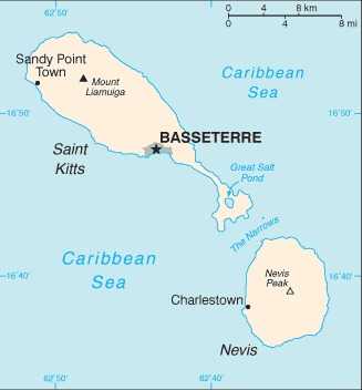
smallest country in the Western Hemisphere in terms of both area and population; the two volcanic islands are separated by a 3-km-wide (9-mi-wide) channel called The Narrows; on the southern tip of baseball-bat-shaped Saint Kitts lies the Great Salt Pond; Nevis Peak sits in the center of its ball-shaped namesake island
Terrain
volcanic with mountainous interiors
Location
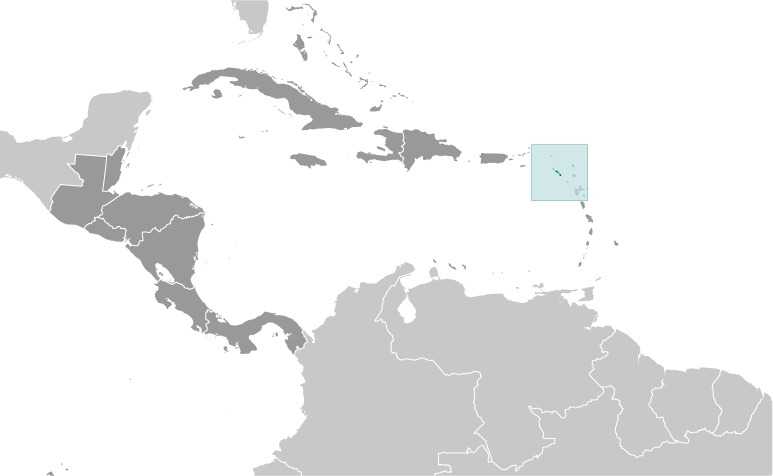
Caribbean, islands in the Caribbean Sea, about one-third of the way from Puerto Rico to Trinidad and Tobago
Map references
Central America and the Caribbean
Irrigated land
8 sq km (2012)
Total renewable water resources
24 million cubic meters (2022 est.)
Population distribution
population clusters are found in the small towns located on the periphery of both islands
Elevation
Highest point: Mount Liamuiga 1,156 m
Lowest point: Caribbean Sea 0 m
Lowest point: Caribbean Sea 0 m
Area
Total : 261 sq km (Saint Kitts 168 sq km; Nevis 93 sq km)
Land: 261 sq km
Water: 0 sq km
Land: 261 sq km
Water: 0 sq km
Age structure
0-14 years: 19.2% (male 5,314/female 5,277)
15-64 years: 68.1% (male 18,944/female 18,575)
65 years and over: 12.7% (2024 est.) (male 3,341/female 3,682)
15-64 years: 68.1% (male 18,944/female 18,575)
65 years and over: 12.7% (2024 est.) (male 3,341/female 3,682)
Sex ratio
At birth: 1.02 male(s)/female
0-14 years: 1.01 male(s)/female
15-64 years: 1.02 male(s)/female
65 years and over: 0.91 male(s)/female
Total population: 1 male(s)/female (2024 est.)
0-14 years: 1.01 male(s)/female
15-64 years: 1.02 male(s)/female
65 years and over: 0.91 male(s)/female
Total population: 1 male(s)/female (2024 est.)
Nationality
Noun: Kittitian(s), Nevisian(s)
Adjective: Kittitian, Nevisian
Adjective: Kittitian, Nevisian
School life expectancy (primary to tertiary education)
Total: 19 years (2015 est.)
Male: 18 years (2015 est.)
Female: 20 years (2015 est.)
Male: 18 years (2015 est.)
Female: 20 years (2015 est.)
Urbanization
Urban population: 31.1% of total population (2023)
Rate of urbanization: 1.06% annual rate of change (2020-25 est.)
Rate of urbanization: 1.06% annual rate of change (2020-25 est.)
Major urban areas - population
14,000 BASSETERRE (capital) (2018)
Hospital bed density
4.3 beds/1,000 population (2021 est.)
Ethnic groups
African descent 92.5%, mixed 3%, White 2.1%, East Indian 1.5%, other 0.6%, unspecified 0.3% (2001 est.)
Languages
English (official)
Physician density
3.09 physicians/1,000 population (2018)
Health expenditure
6.2% of GDP (2021)
5.9% of national budget (2022 est.)
5.9% of national budget (2022 est.)
Dependency ratios
Total dependency ratio: 46.9 (2024 est.)
Youth dependency ratio: 28.2 (2024 est.)
Elderly dependency ratio: 18.7 (2024 est.)
Potential support ratio: 5.3 (2024 est.)
Youth dependency ratio: 28.2 (2024 est.)
Elderly dependency ratio: 18.7 (2024 est.)
Potential support ratio: 5.3 (2024 est.)
Maternal mortality ratio
74 deaths/100,000 live births (2023 est.)
Population
Total: 55,133 (2024 est.)
Male: 27,599
Female: 27,534
Male: 27,599
Female: 27,534
Obesity - adult prevalence rate
22.9% (2016)
Alcohol consumption per capita
Total: 8.84 liters of pure alcohol (2019 est.)
Beer: 3.73 liters of pure alcohol (2019 est.)
Wine: 1.02 liters of pure alcohol (2019 est.)
Spirits: 3.89 liters of pure alcohol (2019 est.)
Other alcohols: 0.21 liters of pure alcohol (2019 est.)
Beer: 3.73 liters of pure alcohol (2019 est.)
Wine: 1.02 liters of pure alcohol (2019 est.)
Spirits: 3.89 liters of pure alcohol (2019 est.)
Other alcohols: 0.21 liters of pure alcohol (2019 est.)
Life expectancy at birth
Total population: 77.6 years (2024 est.)
Male: 75.2 years
Female: 80.1 years
Male: 75.2 years
Female: 80.1 years
Education expenditure
3.5% of GDP (2023 est.)
11% national budget (2025 est.)
11% national budget (2025 est.)
Gross reproduction rate
0.87 (2025 est.)
Net migration rate
1.14 migrant(s)/1,000 population (2025 est.)
Median age
Total: 39.1 years (2025 est.)
Male: 38.8 years
Female: 38.3 years
Male: 38.8 years
Female: 38.3 years
Total fertility rate
1.76 children born/woman (2025 est.)
Infant mortality rate
Total: 7.9 deaths/1,000 live births (2025 est.)
Male: 5.5 deaths/1,000 live births
Female: 10.6 deaths/1,000 live births
Male: 5.5 deaths/1,000 live births
Female: 10.6 deaths/1,000 live births
Death rate
7.43 deaths/1,000 population (2025 est.)
Birth rate
11.58 births/1,000 population (2025 est.)
Population growth rate
0.53% (2025 est.)
Total water withdrawal
Municipal: 15.4 million cubic meters (2022 est.)
Industrial: 0 cubic meters (2022 est.)
Agricultural: 200,000 cubic meters (2022 est.)
Industrial: 0 cubic meters (2022 est.)
Agricultural: 200,000 cubic meters (2022 est.)
Waste and recycling
Municipal solid waste generated annually: 32,900 tons (2024 est.)
Particulate matter emissions
8 micrograms per cubic meter (2019 est.)
Carbon dioxide emissions
269,000 metric tonnes of CO2 (2023 est.)
From petroleum and other liquids: 269,000 metric tonnes of CO2 (2023 est.)
From petroleum and other liquids: 269,000 metric tonnes of CO2 (2023 est.)
Energy consumption per capita
81.454 million Btu/person (2023 est.)
Diplomatic representation from the US
Embassy: The US does not have an embassy in Saint Kitts and Nevis; the US Ambassador to Barbados is accredited to Saint Kitts and Nevis
Administrative divisions
14 parishes; Christ Church Nichola Town, Saint Anne Sandy Point, Saint George Basseterre, Saint George Gingerland, Saint James Windward, Saint John Capesterre, Saint John Figtree, Saint Mary Cayon, Saint Paul Capesterre, Saint Paul Charlestown, Saint Peter Basseterre, Saint Thomas Lowland, Saint Thomas Middle Island, Trinity Palmetto Point
Capital
Name: Basseterre
Geographic coordinates: 17 18 N, 62 43 W
Time difference: UTC-4 (1 hour ahead of Washington, DC, during Standard Time)
Etymology: The French name translates as "low land" in English; the reference is probably to the city's location in a valley
Geographic coordinates: 17 18 N, 62 43 W
Time difference: UTC-4 (1 hour ahead of Washington, DC, during Standard Time)
Etymology: The French name translates as "low land" in English; the reference is probably to the city's location in a valley
Constitution
History: Several previous (pre-independence); latest presented 22 June 1983, effective 23 June 1983
Amendment process: Proposed by the National Assembly; passage requires approval by at least two-thirds majority vote of the total Assembly membership and assent of the governor general; amendments to constitutional provisions such as the sovereignty of the federation, fundamental rights and freedoms, the judiciary, and the Nevis Island Assembly also require approval in a referendum by at least two thirds of the votes cast in Saint Kitts and in Nevis
Amendment process: Proposed by the National Assembly; passage requires approval by at least two-thirds majority vote of the total Assembly membership and assent of the governor general; amendments to constitutional provisions such as the sovereignty of the federation, fundamental rights and freedoms, the judiciary, and the Nevis Island Assembly also require approval in a referendum by at least two thirds of the votes cast in Saint Kitts and in Nevis
Executive branch
Chief of state: King CHARLES III (since 8 September 2022); represented by Governor General Marcella LIBURD (since 1 February 2023)
Head of government: Prime Minister Dr. Terrance DREW (since 6 August 2022)
Cabinet: Cabinet appointed by governor general in consultation with prime minister
Election/appointment process: The monarchy is hereditary; governor general appointed by the monarch; following legislative elections, the governor general usually appoints the leader of the majority party or majority coalition as prime minister; deputy prime minister also appointed by governor general
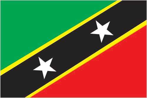
Flag
Description: Divided diagonally from the lower left side by a broad black band with two five-pointed white stars; the black band is edged in yellow; the upper triangle is green, and the lower is red
Meaning: Green stands for the island's fertility, red for the struggles of the people from slavery, yellow for year-round sunshine, and black for the people's African heritage; the white stars stand for the islands of Saint Kitts and Nevis but can also express hope and liberty, or independence and optimism
Meaning: Green stands for the island's fertility, red for the struggles of the people from slavery, yellow for year-round sunshine, and black for the people's African heritage; the white stars stand for the islands of Saint Kitts and Nevis but can also express hope and liberty, or independence and optimism
Independence
19 September 1983 (from the UK)
Judicial branch
Highest court(s): The Eastern Caribbean Supreme Court (ECSC) is the superior court of the Organization of Eastern Caribbean States; the ECSC is headquartered on St. Lucia and consists of the Court of Appeal -- headed by the chief justice and 4 judges -- and the High Court with 18 judges; the Court of Appeal travels to member states on a schedule to hear appeals from the High Court and subordinate courts; member of the Caribbean Court of Justice
Judge selection and term of office: Chief justice of Eastern Caribbean Supreme Court appointed by the British monarch; other justices and judges appointed by the Judicial and Legal Services Commission, an independent body of judicial officials; Court of Appeal justices appointed for life with mandatory retirement at age 65; High Court judges appointed for life with mandatory retirement at age 62
Subordinate courts: Magistrates' courts
Legal system
English common law
Legislative branch
Legislature name: National Assembly
Legislative structure: Unicameral
Number of seats: 16 (11 directly elected; 4 appointed)
Electoral system: Plurality/majority
Scope of elections: Full renewal
Term in office: 5 years
Most recent election date: 8/5/2022
Parties elected and seats per party: St. Kitts-Nevis Labour Party (SKNLP) (6); Concerned Citizens' Movement (CCM) (3); Peoples Labour Party (PLP) (1); People's Action Movement (PAM) (1)
Percentage of women in chamber: 31.3%
Expected date of next election: October 2027
International organization participation
ACP, ACS, AOSIS, C, Caricom, CDB, CELAC, FAO, G-77, IBRD, ICAO, ICCt, ICRM, IDA, IFAD, IFC, IFRCS, ILO, IMF, IMO, Interpol, IOC, ITU, MIGA, OAS, OECS, OPANAL, OPCW, Petrocaribe, UN, UNCTAD, UNESCO, UNIDO, UPU, WHO, WIPO, WTO
National holiday
Independence Day, 19 September (1983)
Political parties
Concerned Citizens Movement or CCM
Nevis Reformation Party or NRP
People's Action Movement or PAM
People's Labour Party or PLP
Saint Kitts and Nevis Labor Party or SKNLP
Nevis Reformation Party or NRP
People's Action Movement or PAM
People's Labour Party or PLP
Saint Kitts and Nevis Labor Party or SKNLP
Suffrage
18 years of age; universal
Government type
federal parliamentary democracy under a constitutional monarchy; a Commonwealth realm
Country name
Conventional long form: Federation of Saint Kitts and Nevis
Conventional short form: Saint Kitts and Nevis
Former: Federation of Saint Christopher and Nevis
Etymology: Explorer Christopher COLUMBUS visited the islands in 1493 and named one for his own patron saint; a common nickname for Christopher during the following centuries was Kit or Kitt, and Saint Kitts is still referred to as Saint Christopher; the name of Nevis is said to derive from the original Spanish name "Las Nieves" (The Snows) and refers to its cloud-topped mountain
Note: Nevis is pronounced NEE-vis
Diplomatic representation in the US
Chief of mission: Ambassador Jacinth HENRY-MARTIN (since 15 September 2023)
Chancery: 1203 19th St. NW, 5th Floor, Washington, DC 20036
Telephone: [1] (202) 686-2636
FAX: [1] (202) 686-5740
Email address and website:
Stkittsnevis@embskn.com
Embassy of St.Kitts and Nevis to the USA – and Permanent Mission to the OAS (embassydc.gov.kn)
Consulate(s) general: Los Angeles, New York
National anthem(s)
Title: "O Land of Beauty!"
Lyrics/music: Kenrick Anderson GEORGES
History: Adopted 1983
Title: "God Save the King"
Lyrics/music: Unknown
History: In use since 1745
Lyrics/music: Kenrick Anderson GEORGES
History: Adopted 1983
Title: "God Save the King"
Lyrics/music: Unknown
History: In use since 1745
International law organization participation
has not submitted an ICJ jurisdiction declaration; accepts ICCt jurisdiction
National symbol(s)
brown pelican, royal poinciana (flamboyant) tree
Citizenship
Citizenship by birth: Yes
Citizenship by descent only: Yes
Dual citizenship recognized: Yes
Residency requirement for naturalization: 14 years
Citizenship by descent only: Yes
Dual citizenship recognized: Yes
Residency requirement for naturalization: 14 years
National heritage
Total World Heritage Sites: 1 (cultural)
Selected World Heritage Site locales: Brimstone Hill Fortress National Park
Selected World Heritage Site locales: Brimstone Hill Fortress National Park
National color(s)
green, yellow, red, black, white
Exports - commodities
ships, measuring instruments, beer, electrical transformers, electrical control boards (2023)
note: top five export commodities based on value in dollars
note: top five export commodities based on value in dollars
Exports - partners
Malta 49%, USA 21%, Turkey 7%, St. Vincent & the Grenadines 5%, Guyana 3% (2023)
note: top five export partners based on percentage share of exports
note: top five export partners based on percentage share of exports
Agricultural products
coconuts, tropical fruits, root vegetables, vegetables, eggs, pulses, sweet potatoes, watermelons, cucumbers/gherkins, tomatoes (2023)
note: top ten agricultural products based on tonnage
note: top ten agricultural products based on tonnage
Budget
Revenues: $262 million (2020 est.)
Expenditures: $281.889 million (2020 est.)
note: central government revenues and expenses (excluding grants/extrabudgetary units/social security funds) converted to US dollars at average official exchange rate for year indicated
Expenditures: $281.889 million (2020 est.)
note: central government revenues and expenses (excluding grants/extrabudgetary units/social security funds) converted to US dollars at average official exchange rate for year indicated
Imports - commodities
refined petroleum, ships, cars, jewelry, poultry (2023)
note: top five import commodities based on value in dollars
note: top five import commodities based on value in dollars
Exchange rates
East Caribbean dollars (XCD) per US dollar -
Exchange rates:
2.7 (2024 est.)
2.7 (2023 est.)
2.7 (2022 est.)
2.7 (2021 est.)
2.7 (2020 est.)
Exchange rates:
2.7 (2024 est.)
2.7 (2023 est.)
2.7 (2022 est.)
2.7 (2021 est.)
2.7 (2020 est.)
Industries
tourism, cotton, salt, copra, clothing, footwear, beverages
Economic overview
high-income, tourism-based Caribbean OECS economy; better debt balancing; CARICOM and ECCU member; growing offshore financial and telecommunications hub; environmentally fragile; unique citizenship-driven growth model
GDP (official exchange rate)
$1.067 billion (2024 est.)
note: data in current dollars at official exchange rate
note: data in current dollars at official exchange rate
Imports - partners
USA 50%, Italy 11%, China 8%, Japan 2%, UK 2% (2023)
note: top five import partners based on percentage share of imports
note: top five import partners based on percentage share of imports
Remittances
3.4% of GDP (2024 est.)
3.5% of GDP (2023 est.)
3.8% of GDP (2022 est.)
note: personal transfers and compensation between resident and non-resident individuals/households/entities
3.5% of GDP (2023 est.)
3.8% of GDP (2022 est.)
note: personal transfers and compensation between resident and non-resident individuals/households/entities
Reserves of foreign exchange and gold
$294.748 million (2024 est.)
$286.075 million (2023 est.)
$293.98 million (2022 est.)
note: holdings of gold (year-end prices)/foreign exchange/special drawing rights in current dollars
$286.075 million (2023 est.)
$293.98 million (2022 est.)
note: holdings of gold (year-end prices)/foreign exchange/special drawing rights in current dollars
Public debt
62.9% of GDP (2017 est.)
note: central government debt as a % of GDP
note: central government debt as a % of GDP
Taxes and other revenues
15% (of GDP) (2020 est.)
note: central government tax revenue as a % of GDP
note: central government tax revenue as a % of GDP
Real GDP (purchasing power parity)
$1.465 billion (2024 est.)
$1.448 billion (2023 est.)
$1.388 billion (2022 est.)
note: data in 2021 dollars
$1.448 billion (2023 est.)
$1.388 billion (2022 est.)
note: data in 2021 dollars
Inflation rate (consumer prices)
3.6% (2023 est.)
2.7% (2022 est.)
1.2% (2021 est.)
note: annual % change based on consumer prices
2.7% (2022 est.)
1.2% (2021 est.)
note: annual % change based on consumer prices
Current account balance
-$169.221 million (2024 est.)
-$122.386 million (2023 est.)
-$111.685 million (2022 est.)
note: balance of payments - net trade and primary/secondary income in current dollars
-$122.386 million (2023 est.)
-$111.685 million (2022 est.)
note: balance of payments - net trade and primary/secondary income in current dollars
Real GDP per capita
$31,300 (2024 est.)
$31,000 (2023 est.)
$29,700 (2022 est.)
note: data in 2021 dollars
$31,000 (2023 est.)
$29,700 (2022 est.)
note: data in 2021 dollars
Imports
$642.934 million (2024 est.)
$669.168 million (2023 est.)
$606.856 million (2022 est.)
note: balance of payments - imports of goods and services in current dollars
$669.168 million (2023 est.)
$606.856 million (2022 est.)
note: balance of payments - imports of goods and services in current dollars
Exports
$504.391 million (2024 est.)
$579.568 million (2023 est.)
$542.983 million (2022 est.)
note: balance of payments - exports of goods and services in current dollars
$579.568 million (2023 est.)
$542.983 million (2022 est.)
note: balance of payments - exports of goods and services in current dollars
Real GDP growth rate
1.2% (2024 est.)
4.3% (2023 est.)
10.3% (2022 est.)
note: annual GDP % growth based on constant local currency
4.3% (2023 est.)
10.3% (2022 est.)
note: annual GDP % growth based on constant local currency
Industrial production growth rate
-2.7% (2024 est.)
note: annual % change in industrial value added based on constant local currency
note: annual % change in industrial value added based on constant local currency
GDP - composition, by sector of origin
Agriculture: 1.3% (2024 est.)
Industry: 21.1% (2024 est.)
Services: 65.5% (2024 est.)
note: figures may not total 100% due to non-allocated consumption not captured in sector-reported data
Industry: 21.1% (2024 est.)
Services: 65.5% (2024 est.)
note: figures may not total 100% due to non-allocated consumption not captured in sector-reported data
Electricity access
Electrification - total population: 100% (2022 est.)
Electricity generation sources
Fossil fuels: 95% of total installed capacity (2023 est.)
Solar: 2.3% of total installed capacity (2023 est.)
Wind: 2.7% of total installed capacity (2023 est.)
Solar: 2.3% of total installed capacity (2023 est.)
Wind: 2.7% of total installed capacity (2023 est.)
Petroleum
Refined petroleum consumption: 2,000 bbl/day (2023 est.)
Electricity
Installed generating capacity: 72,000 kW (2023 est.)
Consumption: 182.455 million kWh (2023 est.)
Transmission/distribution losses: 39.522 million kWh (2023 est.)
Consumption: 182.455 million kWh (2023 est.)
Transmission/distribution losses: 39.522 million kWh (2023 est.)
Internet users
Percent of population: 76% (2022 est.)
Internet country code
.kn
Broadcast media
national state-operated TV network that broadcasts on 2 channels; cable subscription available for local and international channels; national state-operated radio network; mix of state-owned and privately owned broadcasters with about 15 radio stations (2019)
Telephones - mobile cellular
Total subscriptions: 56,000 (2023 est.)
Subscriptions per 100 inhabitants: 119 (2021 est.)
Subscriptions per 100 inhabitants: 119 (2021 est.)
Broadband - fixed subscriptions
Total: 22,000 (2022 est.)
Subscriptions per 100 inhabitants: 47 (2022 est.)
Subscriptions per 100 inhabitants: 47 (2022 est.)
Telephones - fixed lines
Total subscriptions: 16,000 (2022 est.)
Subscriptions per 100 inhabitants: 33 (2022 est.)
Subscriptions per 100 inhabitants: 33 (2022 est.)
Railways
Total: 50 km (2008)
Narrow gauge: 50 km (2008) 0.762-m gauge on Saint Kitts for tourists
Narrow gauge: 50 km (2008) 0.762-m gauge on Saint Kitts for tourists
Civil aircraft registration country code prefix
V4
Airports
2 (2025)
Merchant marine
Total: 341 (2023)
By type: Bulk carrier 22, container ship 16, general cargo 85, oil tanker 59, other 159
By type: Bulk carrier 22, container ship 16, general cargo 85, oil tanker 59, other 159
Heliports
1 (2025)
Military service age and obligation
18 years of age for voluntary military service for men and women (under 18 with written parental permission); no conscription (2025)
Military and security forces
St. Kitts and Nevis Defense Force (SKNDF); Regular Force, Coast Guard Force (SKNDF Coast Guard), Reserve Force, Cadet Force
Ministry of National Security: the Royal St. Christopher and Nevis Police Force (2025)
Ministry of National Security: the Royal St. Christopher and Nevis Police Force (2025)
Military - note
SKNDF's missions include protecting the country's territorial integrity, assisting the police in combating the illegal narcotic trade and other crimes, and providing humanitarian and disaster relief assistance; the force also has a regional role through the Caribbean Regional Security System (RSS); St. Kitts joined the RSS in 1984; RSS signatories (Antigua and Barbuda, Barbados, Dominica, Grenada, Guyana, Saint Lucia, and Saint Vincent and the Grenadines) agreed to prepare contingency plans and assist one another, on request, in national emergencies, prevention of smuggling, search and rescue, immigration control, fishery protection, customs and excise control, maritime policing duties, protection of off-shore installations, pollution control, national and other disasters, and threats to national security (2025)
Military and security service personnel strengths
estimated 200 active Defense Forces (2024)
Military equipment inventories and acquisitions
the SKNDF is lightly armed with equipment from Belgium, the UK, and the US (2025)
Refugees and internally displaced persons
Refugees: 5 (2024 est.)
Ports
Total ports: 2 (2024)
Large: 0
Medium: 0
Small: 0
Very small: 2
Ports with oil terminals: 2
Key ports: Basseterre, Charlestown
Large: 0
Medium: 0
Small: 0
Very small: 2
Ports with oil terminals: 2
Key ports: Basseterre, Charlestown
National coat of arms
the coat of arms of Saint Kitts and Nevis features a Carib who represents the original inhabitants of the islands, and a fleur-de-lis and rose that represent the French and English who arrived in the 1620; the shield also features the poinciana (the national flower) and a traditional boat; three hands hold the torch, which represents the quest for freedom: the hand of an African, a European, and a person of mixed ethnicity; pelicans (the national bird) support the shield, with a sugarcane plant and a coconut tree that symbolize the land
Quick Facts
Also in Central America and the Caribbean
AnguillaAntigua and BarbudaArubaBahamas, TheBarbadosBelizeBritish Virgin IslandsCayman IslandsCosta RicaCuba
View all →