Panama
Central America and the CaribbeanPM December 19, 2025
Background
Explored and settled by the Spanish in the 16th century, Panama broke with Spain in 1821 and joined a union of Colombia, Ecuador, and Venezuela that was named the Republic of Gran Colombia. When the union dissolved in 1830, Panama remained part of Colombia. With US backing, Panama seceded from Colombia in 1903 and promptly signed a treaty with the US allowing for the construction of a canal and US sovereignty over a strip of land known as the Panama Canal Zone on either side of the structure. The US Army Corps of Engineers built the Panama Canal between 1904 and 1914. In 1977, an agreement was signed for the complete transfer of the Canal from the US to Panama by the end of the century. Certain portions of the Zone and increasing responsibility over the Canal were turned over in the subsequent decades. With US help, Panamanian dictator Manuel NORIEGA was deposed in 1989. The entire Panama Canal, the area supporting the Canal, and remaining US military bases were transferred to Panama by the end of 1999. An ambitious expansion project to more than double the Canal's capacity by allowing for more Canal transits and larger ships was carried out between 2007 and 2016.
Geographic coordinates
9 00 N, 80 00 W
Natural hazards
occasional severe storms and forest fires in the Darien area
Area - comparative
slightly smaller than South Carolina
Environmental issues
water pollution from agricultural runoff; deforestation of tropical rainforest; land degradation and soil erosion in Panama Canal; air pollution in urban areas; effects of mining
International environmental agreements
Party to: Antarctic-Marine Living Resources, Biodiversity, Climate Change, Climate Change-Kyoto Protocol, Climate Change-Paris Agreement, Comprehensive Nuclear Test Ban, Desertification, Endangered Species, Environmental Modification, Hazardous Wastes, Law of the Sea, Marine Dumping-London Convention, Nuclear Test Ban, Ozone Layer Protection, Ship Pollution, Tropical Timber 2006, Wetlands, Whaling
Signed, but not ratified: Marine Life Conservation
Signed, but not ratified: Marine Life Conservation
Climate
tropical maritime; hot, humid, cloudy; prolonged rainy season (May to January), short dry season (January to May)
Coastline
2,490 km
Land boundaries
Total: 687 km
Border countries (2): Colombia 339 km; Costa Rica 348 km
Border countries (2): Colombia 339 km; Costa Rica 348 km
Land use
Agricultural land: 29.5% (2023 est.)
Arable land: 7.6% (2023 est.)
Permanent crops: 1.6% (2023 est.)
Permanent pasture: 20.3% (2023 est.)
Forest: 62.3% (2023 est.)
Other: 8.2% (2023 est.)
Arable land: 7.6% (2023 est.)
Permanent crops: 1.6% (2023 est.)
Permanent pasture: 20.3% (2023 est.)
Forest: 62.3% (2023 est.)
Other: 8.2% (2023 est.)
Maritime claims
Territorial sea: 12 nm
Contiguous zone: 24 nm
Exclusive economic zone: 200 nm or edge of continental margin
Contiguous zone: 24 nm
Exclusive economic zone: 200 nm or edge of continental margin
Natural resources
copper, mahogany forests, shrimp, hydropower
Geography - note
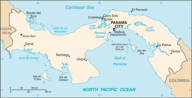
strategic location on eastern end of isthmus forming land bridge that connects North and South America; controls the Panama Canal, which links the North Atlantic Ocean with the North Pacific Ocean via the Caribbean Sea
Terrain
interior mostly steep, rugged mountains with dissected, upland plains; coastal plains with rolling hills
Location
Central America, bordering both the Caribbean Sea and the North Pacific Ocean, between Colombia and Costa Rica
Map references
Central America and the Caribbean
Irrigated land
394 sq km (2022)
Total renewable water resources
139.304 billion cubic meters (2022 est.)
Population distribution
population is concentrated towards the center of the country, particularly around the Canal, but a sizeable segment of the populace also lives in the far west around David; the eastern third of the country is sparsely inhabited
Elevation
Highest point: Volcan Baru 3,475 m
Lowest point: Pacific Ocean 0 m
Mean elevation: 360 m
Lowest point: Pacific Ocean 0 m
Mean elevation: 360 m
Major lakes (area sq km)
Salt water lake(s): Laguna de Chiriqui - 900 sq km
Area
Total : 75,420 sq km
Land: 74,340 sq km
Water: 1,080 sq km
Land: 74,340 sq km
Water: 1,080 sq km
Age structure
0-14 years: 25% (male 574,336/female 544,180)
15-64 years: 64.8% (male 1,465,907/female 1,433,023)
65 years and over: 10.1% (2024 est.) (male 211,014/female 241,781)
15-64 years: 64.8% (male 1,465,907/female 1,433,023)
65 years and over: 10.1% (2024 est.) (male 211,014/female 241,781)
Sex ratio
At birth: 1.06 male(s)/female
0-14 years: 1.06 male(s)/female
15-64 years: 1.02 male(s)/female
65 years and over: 0.87 male(s)/female
Total population: 1.02 male(s)/female (2024 est.)
0-14 years: 1.06 male(s)/female
15-64 years: 1.02 male(s)/female
65 years and over: 0.87 male(s)/female
Total population: 1.02 male(s)/female (2024 est.)
Literacy
Total population: 96.3% (2024 est.)
Male: 97.3% (2024 est.)
Female: 95.9% (2024 est.)
Male: 97.3% (2024 est.)
Female: 95.9% (2024 est.)
Nationality
Noun: Panamanian(s)
Adjective: Panamanian
Adjective: Panamanian
School life expectancy (primary to tertiary education)
Total: 13 years (2016 est.)
Male: 12 years (2016 est.)
Female: 14 years (2016 est.)
Male: 12 years (2016 est.)
Female: 14 years (2016 est.)
Urbanization
Urban population: 69.5% of total population (2023)
Rate of urbanization: 1.92% annual rate of change (2020-25 est.)
Rate of urbanization: 1.92% annual rate of change (2020-25 est.)
Drinking water source
Improved:
Urban: 98.5% of population (2022 est.)
Rural: 86.1% of population (2022 est.)
Total: 94.7% of population (2022 est.)
Unimproved:
Urban: 1.5% of population (2022 est.)
Rural: 13.9% of population (2022 est.)
Total: 5.3% of population (2022 est.)
Urban: 98.5% of population (2022 est.)
Rural: 86.1% of population (2022 est.)
Total: 94.7% of population (2022 est.)
Unimproved:
Urban: 1.5% of population (2022 est.)
Rural: 13.9% of population (2022 est.)
Total: 5.3% of population (2022 est.)
Major urban areas - population
1.977 million PANAMA CITY (capital) (2023)
Physician density
1.63 physicians/1,000 population (2022)
Hospital bed density
1.9 beds/1,000 population (2020 est.)
Dependency ratios
Total dependency ratio: 54.2 (2024 est.)
Youth dependency ratio: 38.6 (2024 est.)
Elderly dependency ratio: 15.6 (2024 est.)
Potential support ratio: 6.4 (2024 est.)
Youth dependency ratio: 38.6 (2024 est.)
Elderly dependency ratio: 15.6 (2024 est.)
Potential support ratio: 6.4 (2024 est.)
Sanitation facility access
Improved:
Urban: 96.1% of population (2022 est.)
Rural: 70.1% of population (2022 est.)
Total: 88% of population (2022 est.)
Unimproved:
Urban: 3.9% of population (2022 est.)
Rural: 29.9% of population (2022 est.)
Total: 12% of population (2022 est.)
Urban: 96.1% of population (2022 est.)
Rural: 70.1% of population (2022 est.)
Total: 88% of population (2022 est.)
Unimproved:
Urban: 3.9% of population (2022 est.)
Rural: 29.9% of population (2022 est.)
Total: 12% of population (2022 est.)
Ethnic groups
Mestizo (mixed Indigenous and White) 65%, Indigenous 12.3% (Ngabe 7.6%, Kuna 2.4%, Embera 0.9%, Bugle 0.8%, other 0.4%, unspecified 0.2%), Black or African descent 9.2%, Mulatto 6.8%, White 6.7% (2010 est.)
Religions
Evangelical 55%, Roman Catholic 33.4%, none 10.1%, unspecified 1.5% (2023 est.)
Languages
Spanish (official), Indigenous languages (including Ngabere (Guaymi), Buglere, Kuna, Embera, Wounaan, Naso (Teribe), and Bri Bri), Panamanian English Creole (a mixture of English and Spanish with elements of Ngabere, also known as Guari Guari and Colon Creole), English, Chinese (Yue and Hakka), Arabic, French Creole, other (Yiddish, Hebrew, Korean, Japanese)
Major-language sample(s):
La Libreta Informativa del Mundo, la fuente indispensable de información básica. (Spanish)
The World Factbook, the indispensable source for basic information.
Major-language sample(s):
La Libreta Informativa del Mundo, la fuente indispensable de información básica. (Spanish)
The World Factbook, the indispensable source for basic information.
Health expenditure
9.7% of GDP (2021)
22.2% of national budget (2022 est.)
22.2% of national budget (2022 est.)
Gross reproduction rate
1.14 (2024 est.)
Currently married women (ages 15-49)
53.2% (2023 est.)
Youth unemployment rate (ages 15-24)
Total: 16.8% (2024 est.)
Male: 13.4% (2024 est.)
Female: 22.1% (2024 est.)
note: % of labor force ages 15-24 seeking employment
Male: 13.4% (2024 est.)
Female: 22.1% (2024 est.)
note: % of labor force ages 15-24 seeking employment
Net migration rate
3 migrant(s)/1,000 population (2024 est.)
Median age
Total: 31.5 years (2024 est.)
Male: 31 years
Female: 31.9 years
Male: 31 years
Female: 31.9 years
Maternal mortality ratio
37 deaths/100,000 live births (2023 est.)
Total fertility rate
2.35 children born/woman (2024 est.)
Population
Total: 4,470,241 (2024 est.)
Male: 2,251,257
Female: 2,218,984
Male: 2,251,257
Female: 2,218,984
Infant mortality rate
Total: 14.2 deaths/1,000 live births (2024 est.)
Male: 15.4 deaths/1,000 live births
Female: 12.9 deaths/1,000 live births
Male: 15.4 deaths/1,000 live births
Female: 12.9 deaths/1,000 live births
Tobacco use
Total: 4.5% (2025 est.)
Male: 7.4% (2025 est.)
Female: 1.7% (2025 est.)
Male: 7.4% (2025 est.)
Female: 1.7% (2025 est.)
Obesity - adult prevalence rate
22.7% (2016)
Death rate
5.7 deaths/1,000 population (2024 est.)
Birth rate
17.4 births/1,000 population (2024 est.)
Children under the age of 5 years underweight
2.9% (2019 est.)
Alcohol consumption per capita
Total: 6.54 liters of pure alcohol (2019 est.)
Beer: 5.29 liters of pure alcohol (2019 est.)
Wine: 0.02 liters of pure alcohol (2019 est.)
Spirits: 1.2 liters of pure alcohol (2019 est.)
Other alcohols: 0.02 liters of pure alcohol (2019 est.)
Beer: 5.29 liters of pure alcohol (2019 est.)
Wine: 0.02 liters of pure alcohol (2019 est.)
Spirits: 1.2 liters of pure alcohol (2019 est.)
Other alcohols: 0.02 liters of pure alcohol (2019 est.)
Life expectancy at birth
Total population: 79.2 years (2024 est.)
Male: 76.4 years
Female: 82.2 years
Male: 76.4 years
Female: 82.2 years
Education expenditure
2.5% of GDP (2023 est.)
16.3% national budget (2024 est.)
16.3% national budget (2024 est.)
Population growth rate
1.48% (2024 est.)
Total water withdrawal
Municipal: 759.1 million cubic meters (2022 est.)
Industrial: 6.2 million cubic meters (2022 est.)
Agricultural: 446.1 million cubic meters (2022 est.)
Industrial: 6.2 million cubic meters (2022 est.)
Agricultural: 446.1 million cubic meters (2022 est.)
Waste and recycling
Municipal solid waste generated annually: 1.472 million tons (2024 est.)
Percent of municipal solid waste recycled: 14.2% (2022 est.)
Percent of municipal solid waste recycled: 14.2% (2022 est.)
Particulate matter emissions
11.9 micrograms per cubic meter (2019 est.)
Carbon dioxide emissions
23.458 million metric tonnes of CO2 (2023 est.)
From coal and metallurgical coke: 1.969 million metric tonnes of CO2 (2023 est.)
From petroleum and other liquids: 20.389 million metric tonnes of CO2 (2023 est.)
From consumed natural gas: 1.101 million metric tonnes of CO2 (2023 est.)
From coal and metallurgical coke: 1.969 million metric tonnes of CO2 (2023 est.)
From petroleum and other liquids: 20.389 million metric tonnes of CO2 (2023 est.)
From consumed natural gas: 1.101 million metric tonnes of CO2 (2023 est.)
Energy consumption per capita
78.01 million Btu/person (2023 est.)
Diplomatic representation from the US
Chief of mission: Ambassador Kevin Marino CABRERA (since 5 May 2025)
Embassy: Building 783, Demetrio Basilio Lakas Avenue, Clayton
Mailing address: 9100 Panama City PL, Washington, DC 20521-9100
Telephone: [507] 317-5000
FAX: [507] 317-5568
Email address and website:
Panama-ACS@state.gov
https://pa.usembassy.gov/
Embassy: Building 783, Demetrio Basilio Lakas Avenue, Clayton
Mailing address: 9100 Panama City PL, Washington, DC 20521-9100
Telephone: [507] 317-5000
FAX: [507] 317-5568
Email address and website:
Panama-ACS@state.gov
https://pa.usembassy.gov/
Administrative divisions
10 provinces (provincias, singular - provincia) and 4 indigenous regions* (comarcas); Bocas del Toro, Chiriquí, Coclé, Colon, Darien, Embera-Wounaan*, Guna Yala*, Herrera, Los Santos, Naso Tjer Di*, Ngabe-Bugle*, Panama, Panama Oeste, Veraguas
Capital
Name: Panama City
Geographic coordinates: 8 58 N, 79 32 W
Time difference: UTC-5 (same time as Washington, DC, during Standard Time)
Etymology: Origin is unclear; may come from a Guaraní word meaning "place of many fish"
Geographic coordinates: 8 58 N, 79 32 W
Time difference: UTC-5 (same time as Washington, DC, during Standard Time)
Etymology: Origin is unclear; may come from a Guaraní word meaning "place of many fish"
Constitution
History: Several previous; latest effective 11 October 1972
Amendment process: Proposed by the National Assembly, by the Cabinet, or by the Supreme Court of Justice; passage requires approval by one of two procedures: 1) absolute majority vote of the Assembly membership in each of three readings and by absolute majority vote of the next elected Assembly in a single reading without textual modifications; 2) absolute majority vote of the Assembly membership in each of three readings, followed by absolute majority vote of the next elected Assembly in each of three readings with textual modifications, and approval in a referendum
Amendment process: Proposed by the National Assembly, by the Cabinet, or by the Supreme Court of Justice; passage requires approval by one of two procedures: 1) absolute majority vote of the Assembly membership in each of three readings and by absolute majority vote of the next elected Assembly in a single reading without textual modifications; 2) absolute majority vote of the Assembly membership in each of three readings, followed by absolute majority vote of the next elected Assembly in each of three readings with textual modifications, and approval in a referendum
Executive branch
Chief of state: President José Raúl MULINO Quintero (since 1 July 2024)
Head of government: President José Raúl MULINO Quintero (since 1 July 2024)
Cabinet: Cabinet appointed by the president
Election/appointment process: President and vice president directly elected on the same ballot by simple-majority popular vote for a 5-year term; president eligible for a single non-consecutive term)
Most recent election date: 5 May 2024
Election results:
2024: José Raúl MULINO Quintero elected president; percent of vote - José Raúl MULINO Quintero (RM) 34.2%, Ricardo Alberto LOMBANA González (MOCA) 24.6%, Martín Erasto TORRIJOS Espino (PP) 16%, Alberto ROUX Moses (CD) 11.4%, Zulay RODRÍGUEZ Lu (independent) 6.6%, José Gabriel CARRIZO Jaén (PRD) 5.9%, other 1.3%
2019: Laurentino "Nito" CORTIZO Cohen elected president; percent of vote - Laurentino CORTIZO Cohen (PRD) 33.3%, Romulo ROUX (CD) 31%, Ricardo LOMBANA (independent) 18.8%, Jose BLANDON (Panameñista Party) 10.8%, Ana Matilde GOMEZ Ruiloba (independent) 4.8%, other 1.3%
Expected date of next election: May 2029
Note: the president is both chief of state and head of government
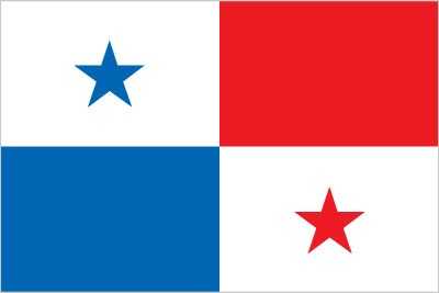
Flag
Description: Divided into four equal rectangles; one of the top quadrants is white (left side) with a five-pointed blue star in the center, and the other is plain red; one of the bottom quadrants is plain blue (left side), and the other is white with a five-pointed red star in the center
Meaning: Blue and red stand for the main political parties, and white for peace between them; the blue star stands for the civic virtues of purity and honesty, and the red star for authority and law
Meaning: Blue and red stand for the main political parties, and white for peace between them; the blue star stands for the civic virtues of purity and honesty, and the red star for authority and law
Independence
3 November 1903 (from Colombia); 28 November 1821 (from Spain)
Judicial branch
Highest court(s): Supreme Court of Justice or Corte Suprema de Justicia (consists of 9 magistrates and 9 alternates and divided into civil, criminal, administrative, and general business chambers)
Judge selection and term of office: Magistrates appointed by the president for staggered 10-year terms
Subordinate courts: Appellate courts or Tribunal Superior; Labor Supreme Courts; Court of Audit; circuit courts or Tribunal Circuital (2 each in 9 of the 10 provinces); municipal courts; electoral, family, maritime, and adolescent courts
Legal system
civil law system; Supreme Court of Justice reviews legislative acts
Legislative branch
Legislature name: National Assembly (Asamblea Nacional)
Legislative structure: Unicameral
Number of seats: 71 (all directly elected)
Electoral system: Mixed system
Scope of elections: Full renewal
Term in office: 5 years
Most recent election date: 5/5/2024
Parties elected and seats per party: Realizing Goals (RM) (14); Democratic Revolutionary Party (PRD) (13); Democratic Change (CD) (8); Panamenista Party (8); Independents (20); Other (8)
Percentage of women in chamber: 21.7%
Expected date of next election: May 2029
International organization participation
ACS, BCIE, CAN (observer), CD, CELAC, FAO, G-77, IADB, IAEA, IBRD, ICAO, ICC (national committees), ICCt, ICRM, IDA, IFAD, IFC, IFRCS, ILO, IMF, IMO, IMSO, Interpol, IOC, IOM, IPU, ISO, ITSO, ITU, ITUC (NGOs), LAES, LAIA, MIGA, NAM, OAS, OPANAL, OPCW, Pacific Alliance (observer), PCA, SICA, UN, UNASUR (observer), UNCTAD, UNESCO, UNIDO, Union Latina, UNOOSA, UNWTO, UPU, WCO, WFTU (NGOs), WHO, WIPO, WMO, WTO
National holiday
Independence Day (Separation Day), 3 November (1903)
Political parties
Alliance Party or PA
Alternative Independent Socialist Party or PAIS
Another Way Movement or MOCA
Democratic Change or CD
Democratic Revolutionary Party or PRD
Nationalist Republican Liberal Movement or MOLIRENA
Panameñista Party (formerly the Arnulfista Party)
Popular Party or PP (formerly Christian Democratic Party or PDC)
Realizing Goals Party or RM
Suffrage
18 years of age; universal
Government type
presidential republic
Country name
Conventional long form: Republic of Panama
Conventional short form: Panama
Local long form: República de Panama
Local short form: Panama
Etymology: Origin is unclear; may come from a Guarani word meaning "place of many fish"
Conventional short form: Panama
Local long form: República de Panama
Local short form: Panama
Etymology: Origin is unclear; may come from a Guarani word meaning "place of many fish"
Diplomatic representation in the US
Chief of mission: Ambassador José Miguel ALEMÁN HEALY (since 18 September 2024)
Chancery: 2862 McGill Terrace NW, Washington, DC 20008
Telephone: [1] (202) 483-1407
FAX: [1] (202) 483-8413
Email address and website:
Info@embassyofpanama.org
https://www.embassyofpanama.org/
Consulate(s) general: Houston, Los Angeles, Miami, New Orleans, New York, Philadelphia, Tampa
Chancery: 2862 McGill Terrace NW, Washington, DC 20008
Telephone: [1] (202) 483-1407
FAX: [1] (202) 483-8413
Email address and website:
Info@embassyofpanama.org
https://www.embassyofpanama.org/
Consulate(s) general: Houston, Los Angeles, Miami, New Orleans, New York, Philadelphia, Tampa
National anthem(s)
Title: "Himno Istmeno" (Isthmus Hymn)
Lyrics/music: Jeronimo DE LA OSSA/Santos A. JORGE
History: Adopted 1925
Lyrics/music: Jeronimo DE LA OSSA/Santos A. JORGE
History: Adopted 1925
International law organization participation
accepts compulsory ICJ jurisdiction with reservations; accepts ICCt jurisdiction
National symbol(s)
harpy eagle
Citizenship
Citizenship by birth: Yes
Citizenship by descent only: Yes
Dual citizenship recognized: No
Residency requirement for naturalization: 5 years
Citizenship by descent only: Yes
Dual citizenship recognized: No
Residency requirement for naturalization: 5 years
National heritage
Total World Heritage Sites: 6 (3 cultural, 3 natural)
Selected World Heritage Site locales: Caribbean Fortifications (c); Darien National Park (n); Talamanca Range-La Amistad National Park (n); Panamá Viejo and Historic District of Panamá (c); Coiba National Park (n); The Colonial Transisthmian Route of Panamá (c)
Selected World Heritage Site locales: Caribbean Fortifications (c); Darien National Park (n); Talamanca Range-La Amistad National Park (n); Panamá Viejo and Historic District of Panamá (c); Coiba National Park (n); The Colonial Transisthmian Route of Panamá (c)
National color(s)
blue, white, red
Population below poverty line
21.8% (2021 est.)
note: % of population with income below national poverty line
note: % of population with income below national poverty line
Household income or consumption by percentage share
Lowest 10%: 1.2% (2023 est.)
Highest 10%: 36.9% (2023 est.)
note: % share of income accruing to lowest and highest 10% of population
Highest 10%: 36.9% (2023 est.)
note: % share of income accruing to lowest and highest 10% of population
Exports - commodities
copper ore, ships, refined petroleum, bananas, fish (2023)
note: top five export commodities based on value in dollars
note: top five export commodities based on value in dollars
Exports - partners
China 25%, Japan 10%, USA 6%, Thailand 5%, Costa Rica 5% (2023)
note: top five export partners based on percentage share of exports
note: top five export partners based on percentage share of exports
Agricultural products
sugarcane, rice, bananas, oranges, oil palm fruit, chicken, plantains, maize, milk, pineapples (2023)
note: top ten agricultural products based on tonnage
note: top ten agricultural products based on tonnage
Budget
Revenues: $7.57 billion (2021 est.)
Expenditures: $12.046 billion (2021 est.)
note: central government revenues and expenses (excluding grants/extrabudgetary units/social security funds) converted to US dollars at average official exchange rate for year indicated
Expenditures: $12.046 billion (2021 est.)
note: central government revenues and expenses (excluding grants/extrabudgetary units/social security funds) converted to US dollars at average official exchange rate for year indicated
Imports - commodities
crude petroleum, ships, refined petroleum, nitrogen compounds, cars (2023)
note: top five import commodities based on value in dollars
note: top five import commodities based on value in dollars
Exchange rates
balboas (PAB) per US dollar -
Exchange rates:
1 (2024 est.)
1 (2023 est.)
1 (2022 est.)
1 (2021 est.)
1 (2020 est.)
Exchange rates:
1 (2024 est.)
1 (2023 est.)
1 (2022 est.)
1 (2021 est.)
1 (2020 est.)
Industries
construction, brewing, cement and other construction materials, sugar milling
Economic overview
upper middle-income Central American economy; increasing Chinese trade; US dollar user; canal expansion fueling broader infrastructure investment; services sector dominates economy; historic money-laundering and illegal drug hub
GDP (official exchange rate)
$86.26 billion (2024 est.)
note: data in current dollars at official exchange rate
note: data in current dollars at official exchange rate
GDP - composition, by end use
Household consumption: 46.7% (2023 est.)
Government consumption: 12.2% (2023 est.)
Investment in fixed capital: 32.3% (2023 est.)
Investment in inventories: 5.4% (2023 est.)
Exports of goods and services: 46.5% (2023 est.)
Imports of goods and services: -43.1% (2023 est.)
note: figures may not total 100% due to rounding or gaps in data collection
Imports - partners
USA 15%, Colombia 13%, China 13%, Ecuador 13%, Japan 11% (2023)
note: top five import partners based on percentage share of imports
note: top five import partners based on percentage share of imports
Average household expenditures
On food: 15.4% of household expenditures (2023 est.)
On alcohol and tobacco: 1.6% of household expenditures (2023 est.)
On alcohol and tobacco: 1.6% of household expenditures (2023 est.)
Remittances
0.6% of GDP (2024 est.)
0.6% of GDP (2023 est.)
0.7% of GDP (2022 est.)
note: personal transfers and compensation between resident and non-resident individuals/households/entities
0.6% of GDP (2023 est.)
0.7% of GDP (2022 est.)
note: personal transfers and compensation between resident and non-resident individuals/households/entities
Labor force
2.206 million (2024 est.)
note: number of people ages 15 or older who are employed or seeking work
note: number of people ages 15 or older who are employed or seeking work
Reserves of foreign exchange and gold
$6.856 billion (2024 est.)
$6.757 billion (2023 est.)
$6.876 billion (2022 est.)
note: holdings of gold (year-end prices)/foreign exchange/special drawing rights in current dollars
$6.757 billion (2023 est.)
$6.876 billion (2022 est.)
note: holdings of gold (year-end prices)/foreign exchange/special drawing rights in current dollars
Unemployment rate
6.6% (2024 est.)
6.6% (2023 est.)
8.1% (2022 est.)
note: % of labor force seeking employment
6.6% (2023 est.)
8.1% (2022 est.)
note: % of labor force seeking employment
Taxes and other revenues
7.5% (of GDP) (2021 est.)
note: central government tax revenue as a % of GDP
note: central government tax revenue as a % of GDP
Real GDP (purchasing power parity)
$164.484 billion (2024 est.)
$159.908 billion (2023 est.)
$148.891 billion (2022 est.)
note: data in 2021 dollars
$159.908 billion (2023 est.)
$148.891 billion (2022 est.)
note: data in 2021 dollars
Inflation rate (consumer prices)
0.7% (2024 est.)
1.5% (2023 est.)
2.9% (2022 est.)
note: annual % change based on consumer prices
1.5% (2023 est.)
2.9% (2022 est.)
note: annual % change based on consumer prices
Current account balance
$1.672 billion (2024 est.)
-$2.581 billion (2023 est.)
$28.769 million (2022 est.)
note: balance of payments - net trade and primary/secondary income in current dollars
-$2.581 billion (2023 est.)
$28.769 million (2022 est.)
note: balance of payments - net trade and primary/secondary income in current dollars
Real GDP per capita
$36,400 (2024 est.)
$35,900 (2023 est.)
$33,800 (2022 est.)
note: data in 2021 dollars
$35,900 (2023 est.)
$33,800 (2022 est.)
note: data in 2021 dollars
Imports
$30.887 billion (2024 est.)
$35.927 billion (2023 est.)
$32.646 billion (2022 est.)
note: balance of payments - imports of goods and services in current dollars
$35.927 billion (2023 est.)
$32.646 billion (2022 est.)
note: balance of payments - imports of goods and services in current dollars
Exports
$37.376 billion (2024 est.)
$37.905 billion (2023 est.)
$35.717 billion (2022 est.)
note: balance of payments - exports of goods and services in current dollars
$37.905 billion (2023 est.)
$35.717 billion (2022 est.)
note: balance of payments - exports of goods and services in current dollars
Real GDP growth rate
2.9% (2024 est.)
7.4% (2023 est.)
10.8% (2022 est.)
note: annual GDP % growth based on constant local currency
7.4% (2023 est.)
10.8% (2022 est.)
note: annual GDP % growth based on constant local currency
Industrial production growth rate
-2.6% (2024 est.)
note: annual % change in industrial value added based on constant local currency
note: annual % change in industrial value added based on constant local currency
GDP - composition, by sector of origin
Agriculture: 2.6% (2024 est.)
Industry: 26.3% (2024 est.)
Services: 68.8% (2024 est.)
note: figures may not total 100% due to non-allocated consumption not captured in sector-reported data
Industry: 26.3% (2024 est.)
Services: 68.8% (2024 est.)
note: figures may not total 100% due to non-allocated consumption not captured in sector-reported data
Electricity access
Electrification - total population: 95% (2022 est.)
Electrification - urban areas: 99%
Electrification - rural areas: 100%
Electrification - urban areas: 99%
Electrification - rural areas: 100%
Coal
Consumption: 863,000 metric tons (2023 est.)
Imports: 863,000 metric tons (2023 est.)
Imports: 863,000 metric tons (2023 est.)
Electricity generation sources
Fossil fuels: 38.2% of total installed capacity (2023 est.)
Solar: 6.8% of total installed capacity (2023 est.)
Wind: 6.9% of total installed capacity (2023 est.)
Hydroelectricity: 47.8% of total installed capacity (2023 est.)
Biomass and waste: 0.3% of total installed capacity (2023 est.)
Solar: 6.8% of total installed capacity (2023 est.)
Wind: 6.9% of total installed capacity (2023 est.)
Hydroelectricity: 47.8% of total installed capacity (2023 est.)
Biomass and waste: 0.3% of total installed capacity (2023 est.)
Natural gas
Consumption: 564.786 million cubic meters (2023 est.)
Imports: 564.786 million cubic meters (2023 est.)
Imports: 564.786 million cubic meters (2023 est.)
Petroleum
Refined petroleum consumption: 131,000 bbl/day (2023 est.)
Electricity
Installed generating capacity: 4.485 million kW (2023 est.)
Consumption: 11.777 billion kWh (2023 est.)
Exports: 404.9 million kWh (2023 est.)
Imports: 234 million kWh (2023 est.)
Transmission/distribution losses: 924.16 million kWh (2023 est.)
Consumption: 11.777 billion kWh (2023 est.)
Exports: 404.9 million kWh (2023 est.)
Imports: 234 million kWh (2023 est.)
Transmission/distribution losses: 924.16 million kWh (2023 est.)
Internet users
Percent of population: 78% (2023 est.)
Internet country code
.pa
Broadcast media
multiple privately owned TV networks and a government-owned educational TV station; multi-channel cable and satellite TV subscription services are available; more than 100 commercial radio stations (2019)
Telephones - mobile cellular
Total subscriptions: 6.98 million (2023 est.)
Subscriptions per 100 inhabitants: 156 (2022 est.)
Subscriptions per 100 inhabitants: 156 (2022 est.)
Broadband - fixed subscriptions
Total: 809,000 (2023 est.)
Subscriptions per 100 inhabitants: 18 (2023 est.)
Subscriptions per 100 inhabitants: 18 (2023 est.)
Telephones - fixed lines
Total subscriptions: 811,000 (2023 est.)
Subscriptions per 100 inhabitants: 18 (2023 est.)
Subscriptions per 100 inhabitants: 18 (2023 est.)
Railways
Total: 77 km (2014)
Standard gauge: 77 km (2014) 1.435-m gauge
Standard gauge: 77 km (2014) 1.435-m gauge
Civil aircraft registration country code prefix
HP
Airports
77 (2025)
Merchant marine
Total: 8,174 (2023)
By type: Bulk carrier 2732, container ship 671, general cargo 1,428, oil tanker 866, other 2,477
By type: Bulk carrier 2732, container ship 671, general cargo 1,428, oil tanker 866, other 2,477
Heliports
1 (2025)
Military - note
the Panamanian Public Forces focus on law enforcement, border control, and maritime security; the National Police are responsible for internal law enforcement and public order, while the National Border Service (SENAFRONT) handles border security; the Aeronaval Service is responsible for carrying out air and naval operations that include some internal security responsibilities; key areas of focus are countering narcotics trafficking and securing the border, particularly along the frontier with Colombia where SENAFRONT maintains a significant presence
Panama created a paramilitary National Guard (Guardia Nacional de Panamá) in the 1950s from the former National Police (established 1904); the National Guard subsequently evolved into more of a military force with some police responsibilities; it seized power in a coup in 1968 and military officers ran the country until 1989; in 1983, the National Guard was renamed the Panama Defense Force (PDF); the PDF was disbanded after the 1989 US invasion and the current national police forces were formed in 1990; the armed forces were officially abolished under the 1994 Constitution (2025)
Panama created a paramilitary National Guard (Guardia Nacional de Panamá) in the 1950s from the former National Police (established 1904); the National Guard subsequently evolved into more of a military force with some police responsibilities; it seized power in a coup in 1968 and military officers ran the country until 1989; in 1983, the National Guard was renamed the Panama Defense Force (PDF); the PDF was disbanded after the 1989 US invasion and the current national police forces were formed in 1990; the armed forces were officially abolished under the 1994 Constitution (2025)
Military expenditures
1.1% of GDP (2024 est.)
1.1% of GDP (2023 est.)
1.2% of GDP (2022 est.)
1.3% of GDP (2021 est.)
1.4% of GDP (2020 est.)
1.1% of GDP (2023 est.)
1.2% of GDP (2022 est.)
1.3% of GDP (2021 est.)
1.4% of GDP (2020 est.)
Military and security service personnel strengths
approximately 30,000 Ministry of Public Security personnel (2025)
Military and security forces
no regular military forces
Ministry of Public Security: National Police (Policía Nacional, PN), National Aeronaval Service (Servicio Nacional Aeronaval, SENAN), National Border Service (Servicio Nacional de Fronteras, SENAFRONT) (2025)
Note 1: collectively, the security forces are known as the Panamanian Public Forces
Note 2: The PNP includes a special forces directorate with counterterrorism and counternarcotics units; SENAFRONT has four regionally based border security brigades, plus a specialized brigade comprised of special forces, counternarcotics, maritime, and rapid reaction units
Illicit drugs
USG identification:
Major illicit drug-producing and/or drug-transit country (2025)
Major illicit drug-producing and/or drug-transit country (2025)
Refugees and internally displaced persons
Refugees: 10,801 (2024 est.)
Stateless persons: 928 (2024 est.)
Stateless persons: 928 (2024 est.)
Ports
Total ports: 12 (2024)
Large: 0
Medium: 3
Small: 3
Very small: 5
Size unknown: 1
Ports with oil terminals: 5
Key ports: Bahia de las Minas, Balboa, Pedregal, Puerto Armuelles, Puerto Colon, Puerto Cristobal
Large: 0
Medium: 3
Small: 3
Very small: 5
Size unknown: 1
Ports with oil terminals: 5
Key ports: Bahia de las Minas, Balboa, Pedregal, Puerto Armuelles, Puerto Colon, Puerto Cristobal
Terrorist group(s)
Terrorist group(s): Tren de Aragua (TdA)
Note: Details about the history, aims, leadership, organization, areas of operation, tactics, targets, weapons, size, and sources of support of the group(s) appear(s) in the Terrorism reference guide
Note: Details about the history, aims, leadership, organization, areas of operation, tactics, targets, weapons, size, and sources of support of the group(s) appear(s) in the Terrorism reference guide
Gini Index coefficient - distribution of family income
48.9 (2023 est.)
note: index (0-100) of income distribution; higher values represent greater inequality
note: index (0-100) of income distribution; higher values represent greater inequality
Quick Facts
Also in Central America and the Caribbean
AnguillaAntigua and BarbudaArubaBahamas, TheBarbadosBelizeBritish Virgin IslandsCayman IslandsCosta RicaCuba
View all →