Micronesia, Federated States of
Background
Each of the four states that compose the Federated States of Micronesia (FSM) -- Chuuk, Kosrae, Pohnpei, and Yap -- has its own unique history and cultural traditions. The first humans arrived in what is now the FSM in the second millennium B.C. In the 800s A.D., construction of the artificial islets at the Nan Madol complex in Pohnpei began, with the main architecture being built around 1200. At its height, Nan Madol united the approximately 25,000 people of Pohnpei under the Saudeleur Dynasty. By 1250, Kosrae was united in a kingdom centered in Leluh. Yap’s society became strictly hierarchical, with chiefs receiving tributes from islands up to 1,100 km (700 mi) away. Widespread human settlement in Chuuk began in the 1300s, and the different islands in the Chuuk Lagoon were frequently at war with one another.
Portuguese and Spanish explorers visited a few of the islands in the 1500s, and Spain began exerting nominal, but not day-to-day, control over some of the islands -- which they named the Caroline Islands -- in the 1600s. In 1899, Spain sold all of the FSM to Germany. Japan seized the islands in 1914 and was granted a League of Nations mandate to administer them in 1920. The Japanese navy built bases across most of the islands and headquartered their Pacific naval operations in Chuuk. The US bombed Chuuk in 1944 but largely bypassed the other islands in its leapfrog campaign across the Pacific.
In 1947, the FSM came under US administration as part of the Trust Territory of the Pacific Islands, which comprised six districts: Chuuk, the Marshall Islands, the Northern Mariana Islands, Palau, Pohnpei, and Yap; Kosrae was separated from Pohnpei into a separate district in 1977. In 1979, Chuuk, Kosrae, Pohnpei, and Yap ratified the FSM Constitution and declared independence while the other three districts opted to pursue separate political status. There are significant inter-island rivalries stemming from their different histories and cultures. Chuuk, the most populous but poorest state, has pushed for secession, but an independence referendum has been repeatedly postponed.
Geographic coordinates
Natural hazards
Area - comparative
Climate
Coastline
Land boundaries
Maritime claims
Exclusive economic zone: 200 nm
Natural resources
Geography - note
Terrain
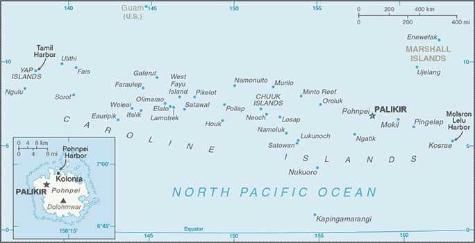
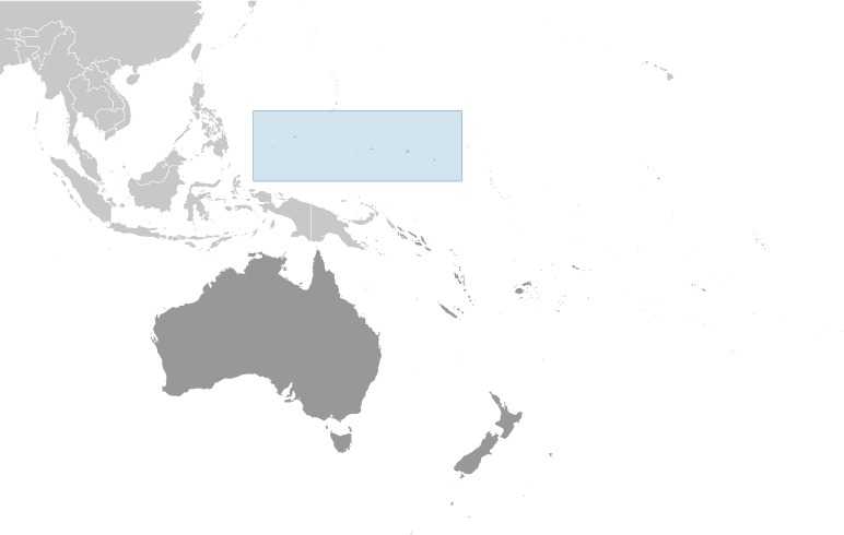
Location
Map references
Irrigated land
Population distribution
Elevation
Lowest point: Pacific Ocean 0 m
Total renewable water resources
Area
Land: 702 sq km
Water: 0 sq km (fresh water only)
Note: Includes Pohnpei (Ponape), Chuuk (Truk) Islands, Yap Islands, and Kosrae (Kosaie)
Land use
Agricultural land: arable land: 2.3% (2018 est.)
Agricultural land: permanent crops: 19.7% (2018 est.)
Agricultural land: permanent pasture: 3.5% (2018 est.)
Forest: 74.5% (2018 est.)
Other: 0% (2018 est.)
Age structure
15-64 years: 67.3% (male 32,527/female 34,487)
65 years and over: 5.7% (2024 est.) (male 2,508/female 3,169)
Sex ratio
0-14 years: 1.03 male(s)/female
15-64 years: 0.94 male(s)/female
65 years and over: 0.79 male(s)/female
Total population: 0.96 male(s)/female (2024 est.)
Nationality
Adjective: Micronesian; Chuukese, Kosraen(s), Pohnpeian(s), Yapese
Urbanization
Rate of urbanization: 1.52% annual rate of change (2020-25 est.)
Drinking water source
Unimproved: Total: 21.4% of population (2017 est.)
Major urban areas - population
Hospital bed density
Dependency ratios
Youth dependency ratio: 48.4
Elderly dependency ratio: 9.3
Potential support ratio: 10.8 (2021 est.)
Sanitation facility access
Rural: NA
Total: 88.3% of population
Unimproved: Urban: NA
Rural: NA
Total: 11.7% of population (2017 est.)
Ethnic groups
Religions
Languages
Contraceptive prevalence rate
Current health expenditure
Literacy
Male: NA
Female: NA
Gross reproduction rate
Currently married women (ages 15-49)
Youth unemployment rate (ages 15-24)
Male: 10.4%
Female: 29.9%
Net migration rate
Median age
Male: 27.3 years
Female: 29.1 years
Maternal mortality ratio
Total fertility rate
Population
Male: 48,708
Female: 50,895 (2024 est.)
Infant mortality rate
Male: 23.8 deaths/1,000 live births
Female: 17.8 deaths/1,000 live births
Obesity - adult prevalence rate
Death rate
Birth rate
Children under the age of 5 years underweight
Alcohol consumption per capita
Beer: 0.92 liters of pure alcohol (2019 est.)
Wine: 0.13 liters of pure alcohol (2019 est.)
Spirits: 0.52 liters of pure alcohol (2019 est.)
Other alcohols: 0.01 liters of pure alcohol (2019 est.)
Life expectancy at birth
Male: 72.9 years
Female: 77.2 years
Population growth rate
Environment - current issues
Environment - international agreements
Signed, but not ratified: None of the selected agreements
Waste and recycling
Carbon dioxide emissions
From petroleum and other liquids: 166,000 metric tonnes of CO2 (2022 est.)
Energy consumption per capita
Diplomatic representation from the US
Embassy: 1286 US Embassy Place, Kolonia, Pohnpei, FM 96941
Mailing address: 4120 Kolonia Place, Washington, D.C. 20521-4120
Telephone: [691] 320-2187
FAX: [691] 320-2186
Email address and website:
Koloniaacs@state.gov
https://fm.usembassy.gov/
Administrative divisions
Capital
Geographic coordinates: 6 55 N, 158 09 E
Time difference: UTC+11 (16 hours ahead of Washington, DC, during Standard Time)
Time zone note: Micronesia has two time zones
Note: Palikir became the new capital of the country in 1989, three years after independence; Kolonia, the former capital, remains the site for many foreign embassies; it also serves as the Pohnpei state capital
Constitution
Amendments: Proposed by Congress, by a constitutional convention, or by public petition; passage requires approval by at least three-fourths majority vote in at least three fourths of the states; amended 1990; note – at least every 10 years as part of a general or special election, voters are asked whether to hold a constitution convention; a majority of affirmative votes is required to proceed; amended many times, last in 2019 (approval by referendum to hold a constitutional convention)
Executive branch
Head of government: President Wesley W. SIMINA (since 12 May 2023)
Cabinet: Cabinet includes the vice president and the heads of the 8 executive departments
Elections/appointments: President and vice president indirectly elected by Congress from among the 4 'at large' senators for a 4-year term (eligible for a second term); election last held on 12 May 2023 (next to be held in 2027)
Note: the president is both chief of state and head of government
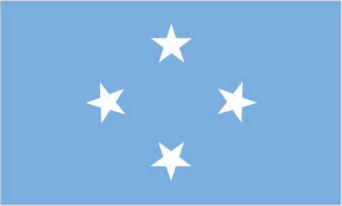
Flag description
Independence
Judicial branch
Judge selection and term of office: Justices appointed by the FSM president with the approval of two-thirds of Congress; justices appointed for life
Subordinate courts: The highest state-level courts are: Chuuk Supreme Court; Korsae State Court; Pohnpei State Court; Yap State Court
Legal system
Legislative branch
Legislative structure: Unicameral
Number of seats: 14 (all directly elected)
Electoral system: Plurality/majority
Scope of elections: Full renewal
Term in office: 2 years
Most recent election date: 3/7/2023
Percentage of women in chamber: 21.4%
Expected date of next election: March 2025
International organization participation
National holiday
Political parties
Suffrage
Government type
Country name
Conventional short form: None
Local long form: Federated States of Micronesia
Local short form: None
Former: New Philippines; Caroline Islands; Trust Territory of the Pacific Islands, Ponape, Truk, and Yap Districts
Abbreviation: FSM
Etymology: The term "Micronesia" is a 19th-century construct of two Greek words, "micro" (small) and "nesoi" (islands), and refers to thousands of small islands in the western Pacific Ocean
Diplomatic representation in the US
Chancery: 1725 N Street NW, Washington, DC 20036
Telephone: [1] (202) 223-4383
FAX: [1] (202) 223-4391
Email address and website:
Dcmission@fsmembassy.fm
https://fsmembassy.fm/
Consulate(s) general: Honolulu, Portland (OR), Tamuning (Guam)
International law organization participation
National symbol(s)
Citizenship
Citizenship by descent only: At least one parent must be a citizen of FSM
Dual citizenship recognized: No
Residency requirement for naturalization: 5 years
National heritage
Selected World Heritage Site locales: Nan Madol: Ceremonial Center of Eastern Micronesia
Exports - commodities
Note: Top export commodities based on value in dollars over $500,000
Agricultural products
note: top ten agricultural products based on tonnage
Budget
Expenditures: $87.355 million (2020 est.)
note: central government revenues and expenses (excluding grants/extrabudgetary units/social security funds) converted to US dollars at average official exchange rate for year indicated
Imports - commodities
note: top five import commodities based on value in dollars
Exchange rates
Industries
Economic overview
GDP (official exchange rate)
note: data in current dollars at official exchange rate
GDP - composition, by end use
Imports of goods and services: -67.5% (2023 est.)
note: figures may not total 100% due to rounding or gaps in data collection
Imports - partners
note: top five import partners based on percentage share of imports
Exports - partners
note: top five export partners based on percentage share of exports
Remittances
5.43% of GDP (2022 est.)
5.98% of GDP (2021 est.)
note: personal transfers and compensation between resident and non-resident individuals/households/entities
Reserves of foreign exchange and gold
$451.913 million (2020 est.)
$397.158 million (2019 est.)
note: holdings of gold (year-end prices)/foreign exchange/special drawing rights in current dollars
Public debt
note: central government debt as a % of GDP
Taxes and other revenues
note: central government tax revenue as a % of GDP
Real GDP (purchasing power parity)
$434.352 million (2022 est.)
$437.759 million (2021 est.)
note: data in 2021 dollars
Inflation rate (consumer prices)
3.19% (2021 est.)
0.55% (2020 est.)
note: annual % change based on consumer prices
Current account balance
$11 million (2016 est.)
$22.408 million (2014 est.)
note: balance of payments - net trade and primary/secondary income in current dollars
Real GDP per capita
$3,900 (2022 est.)
$3,900 (2021 est.)
note: data in 2021 dollars
Imports
$133 million (2020 est.)
$121 million (2019 est.)
note: balance of payments - imports of goods and services in current dollars
Exports
$122 million (2020 est.)
$130 million (2019 est.)
note: balance of payments - exports of goods and services in current dollars
Real GDP growth rate
-0.78% (2022 est.)
2.8% (2021 est.)
note: annual GDP % growth based on constant local currency
Industrial production growth rate
Note: Annual % change in industrial value added based on constant local currency
GDP - composition, by sector of origin
Industry: 4.9% (2023 est.)
Services: 66.8% (2023 est.)
note: figures may not total 100% due to non-allocated consumption not captured in sector-reported data
Electricity access
Electrification - urban areas: 98.6%
Electrification - rural areas: 79.4%
Petroleum
Telecommunication systems
Domestic: Fixed line teledensity roughly 6 per 100 and mobile-cellular nearly 19 per 100 (2021)
International: Country code - 691; landing points for the Chuukk-Pohnpei Cable and HANTRU-1 submarine cable system linking the Federated States of Micronesia and the US; satellite earth stations - 5 Intelsat (Pacific Ocean) (2019)
Internet users
Internet country code
Broadcast media
Telephones - mobile cellular
Subscriptions per 100 inhabitants: 19 (2021 est.)
Broadband - fixed subscriptions
Subscriptions per 100 inhabitants: 6 (2022 est.)
Telephones - fixed lines
Subscriptions per 100 inhabitants: 6 (2022 est.)
Civil aircraft registration country code prefix
Roadways
Note - paved and unpaved circumferential roads, most interior roads are unpaved
Airports
Merchant marine
By type: General cargo 17, oil tanker 4, other 17
Military and security forces
Military - note
The FSM has a "shiprider" agreement with the US, which allows local maritime law enforcement officers to embark on US Coast Guard (USCG) and US Navy (USN) vessels, including to board and search vessels suspected of violating laws or regulations within the FSM's designated exclusive economic zone (EEZ) or on the high seas; "shiprider" agreements also enable USCG personnel and USN vessels with embarked USCG law enforcement personnel to work with host nations to protect critical regional resources (2024)
Illicit drugs
National anthem
Lyrics/music: Unknown/August Daniel BINZER
Note: Adopted 1991; also known as "Across All Micronesia"; the music is based on the 1820 German patriotic song "Ich hab mich ergeben", which was the West German national anthem from 1949-1950; variants of this tune are used in Johannes BRAHMS' "Festival Overture" and Gustav MAHLER's "Third Symphony"
Air pollutants
Carbon dioxide emissions: 0.14 megatons (2016 est.)
Methane emissions: 0.02 megatons (2020 est.)
Ports
Large: 0
Medium: 0
Small: 1
Very small: 3
Ports with oil terminals: 3
Key ports: Colonia, Lele Harbor, Moen, Pohnpei Harbor