Cameroon
AfricaCM December 31, 2025
Background
Powerful chiefdoms ruled much of the area of present-day Cameroon before it became a German colony known as Kamerun in 1884. After World War I, the territory was divided between France and the UK as League of Nations mandates. French Cameroon became independent in 1960 as the Republic of Cameroon. The following year, the southern portion of neighboring British Cameroon voted to merge with the new country to form the Federal Republic of Cameroon. In 1972, a new constitution replaced the federation with a unitary state, the United Republic of Cameroon. The country has generally enjoyed stability, which has enabled the development of agriculture, roads, and railways, as well as a petroleum industry. Nonetheless, unrest and violence in the country's two western, English-speaking regions have persisted since 2016. Movement toward democratic reform is slow, and political power remains firmly in the hands of President Paul BIYA.
Geographic coordinates
6 00 N, 12 00 E
Natural hazards
volcanic activity with periodic releases of poisonous gases from Lake Nyos and Lake Monoun volcanoes
Volcanism: Mt. Cameroon (4,095 m), which last erupted in 2000, is the most frequently active volcano in West Africa; lakes in the Oku volcanic field sometimes release fatal levels of gas, which killed about 1,700 people in 1986
Volcanism: Mt. Cameroon (4,095 m), which last erupted in 2000, is the most frequently active volcano in West Africa; lakes in the Oku volcanic field sometimes release fatal levels of gas, which killed about 1,700 people in 1986
Area - comparative
slightly larger than California; about four times the size of Pennsylvania
Environmental issues
deforestation; overgrazing; soil erosion; desertification; poaching; overfishing; overhunting
International environmental agreements
Party to: Biodiversity, Climate Change, Climate Change-Kyoto Protocol, Climate Change-Paris Agreement, Comprehensive Nuclear Test Ban, Desertification, Endangered Species, Environmental Modification, Hazardous Wastes, Law of the Sea, Ozone Layer Protection, Ship Pollution, Tropical Timber 2006, Wetlands, Whaling
Signed, but not ratified: Nuclear Test Ban
Signed, but not ratified: Nuclear Test Ban
Climate
varies with terrain, from tropical along coast to semiarid and hot in north
Coastline
402 km
Land boundaries
Total: 5,018 km
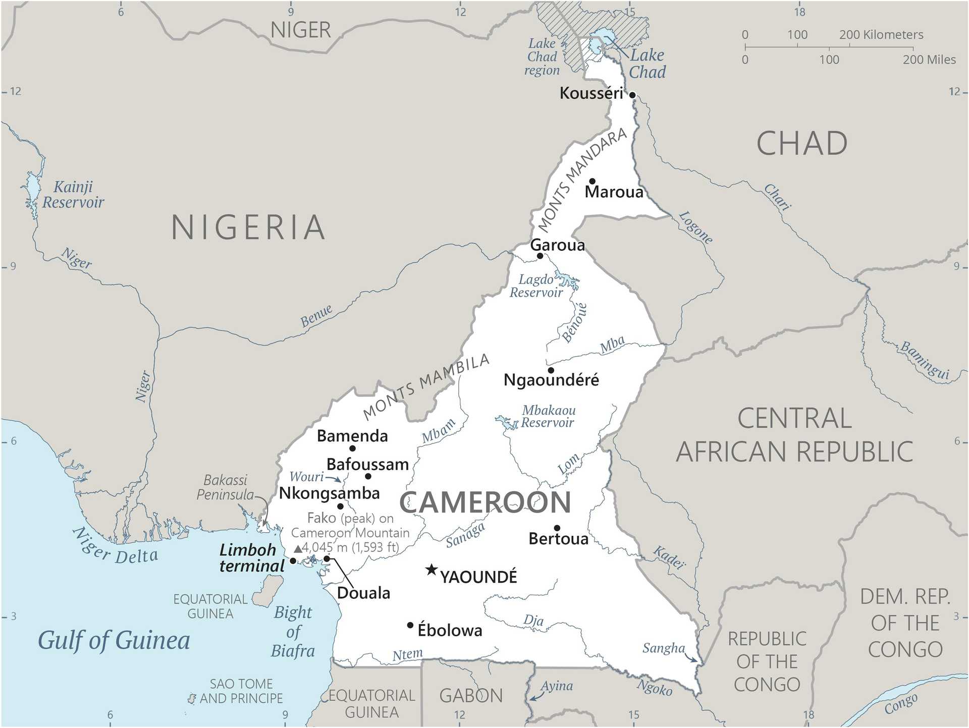
Border countries (6): Central African Republic 901 km; Chad 1,116 km; Republic of the Congo 494 km; Equatorial Guinea 183 km; Gabon 349 km; Nigeria 1975 km
Border countries (6): Central African Republic 901 km; Chad 1,116 km; Republic of the Congo 494 km; Equatorial Guinea 183 km; Gabon 349 km; Nigeria 1975 km
Land use
Agricultural land: 20.9% (2023 est.)
Arable land: 13.1% (2023 est.)
Permanent crops: 3.6% (2023 est.)
Permanent pasture: 4.2% (2023 est.)
Forest: 41% (2023 est.)
Other: 38.1% (2023 est.)
Arable land: 13.1% (2023 est.)
Permanent crops: 3.6% (2023 est.)
Permanent pasture: 4.2% (2023 est.)
Forest: 41% (2023 est.)
Other: 38.1% (2023 est.)
Maritime claims
Territorial sea: 12 nm
Contiguous zone: 24 nm
Contiguous zone: 24 nm
Natural resources
petroleum, bauxite, iron ore, timber, hydropower
Geography - note
sometimes referred to as the hinge of Africa because of its central location on the continent and its position at the west-south juncture of the Gulf of Guinea; areas of thermal springs and indications of current or prior volcanic activity; Mount Cameroon, the highest mountain in Sub-Saharan west Africa, is an active volcano
Terrain
diverse, with coastal plain in southwest, dissected plateau in center, mountains in west, plains in north
Location
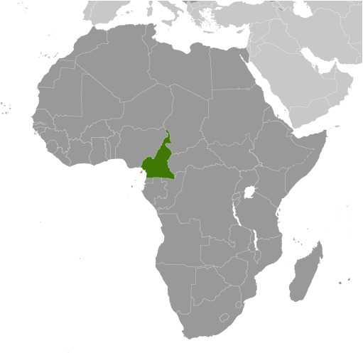
Central Africa, bordering the Bight of Biafra, between Equatorial Guinea and Nigeria
Map references
Africa
Irrigated land
290 sq km (2012)
Total renewable water resources
283.15 billion cubic meters (2022 est.)
Population distribution
population concentrated in the west and north, with the interior of the country sparsely populated, as shown in this population distribution map
Elevation
Highest point: Fako on Mont Cameroun 4,045 m
Lowest point: Atlantic Ocean 0 m
Mean elevation: 667 m
Lowest point: Atlantic Ocean 0 m
Mean elevation: 667 m
Major aquifers
Lake Chad Basin
Major watersheds (area sq km)
Atlantic Ocean drainage: Congo (3,730,881 sq km), Niger (2,261,741 sq km)
Internal (endorheic basin) drainage: Lake Chad (2,497,738 sq km)
Internal (endorheic basin) drainage: Lake Chad (2,497,738 sq km)
Major lakes (area sq km)
Fresh water lake(s): Lake Chad (endorheic lake shared with Niger, Nigeria, and Chad) - 10,360-25,900 sq km
Note - area varies by season and year to year
Note - area varies by season and year to year
Area
Total : 475,440 sq km
Land: 472,710 sq km
Water: 2,730 sq km
Land: 472,710 sq km
Water: 2,730 sq km
Age structure
0-14 years: 41.5% (male 6,477,438/female 6,364,987)
15-64 years: 55.3% (male 8,488,522/female 8,638,519)
65 years and over: 3.2% (2024 est.) (male 463,628/female 533,011)
15-64 years: 55.3% (male 8,488,522/female 8,638,519)
65 years and over: 3.2% (2024 est.) (male 463,628/female 533,011)
Sex ratio
At birth: 1.03 male(s)/female
0-14 years: 1.02 male(s)/female
15-64 years: 0.98 male(s)/female
65 years and over: 0.87 male(s)/female
Total population: 0.99 male(s)/female (2024 est.)
0-14 years: 1.02 male(s)/female
15-64 years: 0.98 male(s)/female
65 years and over: 0.87 male(s)/female
Total population: 0.99 male(s)/female (2024 est.)
Literacy
Total population: 72.6% (2018 est.)
Male: 79.7% (2018 est.)
Female: 66.2% (2018 est.)
Male: 79.7% (2018 est.)
Female: 66.2% (2018 est.)
Nationality
Noun: Cameroonian(s)
Adjective: Cameroonian
Adjective: Cameroonian
School life expectancy (primary to tertiary education)
Total: 11 years (2023 est.)
Male: 12 years (2023 est.)
Female: 10 years (2023 est.)
Male: 12 years (2023 est.)
Female: 10 years (2023 est.)
Urbanization
Urban population: 59.3% of total population (2023)
Rate of urbanization: 3.43% annual rate of change (2020-25 est.)
Rate of urbanization: 3.43% annual rate of change (2020-25 est.)
Drinking water source
Improved:
Urban: 81.6% of population (2022 est.)
Rural: 52.5% of population (2022 est.)
Total: 69.6% of population (2022 est.)
Unimproved:
Urban: 18.4% of population (2022 est.)
Rural: 47.5% of population (2022 est.)
Total: 30.4% of population (2022 est.)
Urban: 81.6% of population (2022 est.)
Rural: 52.5% of population (2022 est.)
Total: 69.6% of population (2022 est.)
Unimproved:
Urban: 18.4% of population (2022 est.)
Rural: 47.5% of population (2022 est.)
Total: 30.4% of population (2022 est.)
Major urban areas - population
4.509 million YAOUNDE (capital), 4.063 million Douala (2023)
Physician density
0.14 physicians/1,000 population (2022)
Hospital bed density
2.6 beds/1,000 population (2016 est.)
Mother's mean age at first birth
20.1 years (2018 est.)
Note: Data represents median age at first birth among women 25-49
Note: Data represents median age at first birth among women 25-49
Dependency ratios
Total dependency ratio: 80.8 (2024 est.)
Youth dependency ratio: 75 (2024 est.)
Elderly dependency ratio: 5.8 (2024 est.)
Potential support ratio: 17.2 (2024 est.)
Youth dependency ratio: 75 (2024 est.)
Elderly dependency ratio: 5.8 (2024 est.)
Potential support ratio: 17.2 (2024 est.)
Sanitation facility access
Improved:
Urban: 83.2% of population (2022 est.)
Rural: 27.4% of population (2022 est.)
Total: 60.2% of population (2022 est.)
Unimproved:
Urban: 16.8% of population (2022 est.)
Rural: 72.6% of population (2022 est.)
Total: 39.8% of population (2022 est.)
Urban: 83.2% of population (2022 est.)
Rural: 27.4% of population (2022 est.)
Total: 60.2% of population (2022 est.)
Unimproved:
Urban: 16.8% of population (2022 est.)
Rural: 72.6% of population (2022 est.)
Total: 39.8% of population (2022 est.)
Ethnic groups
Bamileke-Bamu 22.2%, Biu-Mandara 16.4%, Arab-Choa/Hausa/Kanuri 13.5%, Beti/Bassa, Mbam 13.1%, Grassfields 9.9%, Adamawa-Ubangi, 9.8%, Cotier/Ngoe/Oroko 4.6%, Southwestern Bantu 4.3%, Kako/Meka 2.3%, foreign/other ethnic group 3.8% (2022 est.)
Religions
Roman Catholic 33.1%, Muslim 30.6%, Protestant 27.1% other Christian 6.1%, animist 1.3%, other 0.7%, none 1.2% (2022 est.)
Languages
24 major African language groups, English (official), French (official)
Major-language sample(s):
The World Factbook, the indispensable source for basic information. (English)
The World Factbook, une source indispensable d'informations de base. (French)
Major-language sample(s):
The World Factbook, the indispensable source for basic information. (English)
The World Factbook, une source indispensable d'informations de base. (French)
Health expenditure
3.8% of GDP (2021)
3.9% of national budget (2022 est.)
3.9% of national budget (2022 est.)
Child marriage
Women married by age 15: 10.7% (2018)
Women married by age 18: 29.8% (2018)
Men married by age 18: 2.9% (2018)
Women married by age 18: 29.8% (2018)
Men married by age 18: 2.9% (2018)
Gross reproduction rate
2.19 (2024 est.)
Currently married women (ages 15-49)
58.1% (2018 est.)
Youth unemployment rate (ages 15-24)
Total: 6.2% (2024 est.)
Male: 5.9% (2024 est.)
Female: 6.7% (2024 est.)
note: % of labor force ages 15-24 seeking employment
Male: 5.9% (2024 est.)
Female: 6.7% (2024 est.)
note: % of labor force ages 15-24 seeking employment
Net migration rate
-0.3 migrant(s)/1,000 population (2024 est.)
Median age
Total: 18.9 years (2024 est.)
Male: 18.6 years
Female: 19.2 years
Male: 18.6 years
Female: 19.2 years
Maternal mortality ratio
258 deaths/100,000 live births (2023 est.)
Total fertility rate
4.44 children born/woman (2024 est.)
Population
Total: 30,966,105 (2024 est.)
Male: 15,429,588
Female: 15,536,517
Male: 15,429,588
Female: 15,536,517
Infant mortality rate
Total: 46.1 deaths/1,000 live births (2024 est.)
Male: 50.8 deaths/1,000 live births
Female: 41.3 deaths/1,000 live births
Male: 50.8 deaths/1,000 live births
Female: 41.3 deaths/1,000 live births
Tobacco use
Total: 5% (2025 est.)
Male: 9.2% (2025 est.)
Female: 0.9% (2025 est.)
Male: 9.2% (2025 est.)
Female: 0.9% (2025 est.)
Obesity - adult prevalence rate
11.4% (2016)
Death rate
7.4 deaths/1,000 population (2024 est.)
Birth rate
34.7 births/1,000 population (2024 est.)
Children under the age of 5 years underweight
11% (2018 est.)
Alcohol consumption per capita
Total: 4.09 liters of pure alcohol (2019 est.)
Beer: 2.36 liters of pure alcohol (2019 est.)
Wine: 0.16 liters of pure alcohol (2019 est.)
Spirits: 0.01 liters of pure alcohol (2019 est.)
Other alcohols: 1.56 liters of pure alcohol (2019 est.)
Beer: 2.36 liters of pure alcohol (2019 est.)
Wine: 0.16 liters of pure alcohol (2019 est.)
Spirits: 0.01 liters of pure alcohol (2019 est.)
Other alcohols: 1.56 liters of pure alcohol (2019 est.)
Life expectancy at birth
Total population: 64.2 years (2024 est.)
Male: 62.3 years
Female: 66.1 years
Male: 62.3 years
Female: 66.1 years
Education expenditure
2.8% of GDP (2023 est.)
13.8% national budget (2024 est.)
13.8% national budget (2024 est.)
Population growth rate
2.71% (2024 est.)
Total water withdrawal
Municipal: 246.8 million cubic meters (2022 est.)
Industrial: 104.6 million cubic meters (2022 est.)
Agricultural: 737 million cubic meters (2022 est.)
Industrial: 104.6 million cubic meters (2022 est.)
Agricultural: 737 million cubic meters (2022 est.)
Waste and recycling
Municipal solid waste generated annually: 3.271 million tons (2024 est.)
Percent of municipal solid waste recycled: 4.6% (2022 est.)
Percent of municipal solid waste recycled: 4.6% (2022 est.)
Particulate matter emissions
62 micrograms per cubic meter (2019 est.)
Carbon dioxide emissions
6.707 million metric tonnes of CO2 (2023 est.)
From coal and metallurgical coke: 200 metric tonnes of CO2 (2023 est.)
From petroleum and other liquids: 5.658 million metric tonnes of CO2 (2023 est.)
From consumed natural gas: 1.049 million metric tonnes of CO2 (2023 est.)
From coal and metallurgical coke: 200 metric tonnes of CO2 (2023 est.)
From petroleum and other liquids: 5.658 million metric tonnes of CO2 (2023 est.)
From consumed natural gas: 1.049 million metric tonnes of CO2 (2023 est.)
Energy consumption per capita
4.271 million Btu/person (2023 est.)
Diplomatic representation from the US
Chief of mission: Ambassador Christopher J. LAMORA (since 21 March 2022)
Embassy: Avenue Rosa Parks, Yaoundé
Mailing address: 2520 Yaounde Place, Washington, DC 20521-2520
Telephone: [237] 22251-4000
FAX: [237] 22251-4000, Ext. 4531
Email address and website:
YaoundeACS@state.gov
https://cm.usembassy.gov/
Branch office(s): Douala
Embassy: Avenue Rosa Parks, Yaoundé
Mailing address: 2520 Yaounde Place, Washington, DC 20521-2520
Telephone: [237] 22251-4000
FAX: [237] 22251-4000, Ext. 4531
Email address and website:
YaoundeACS@state.gov
https://cm.usembassy.gov/
Branch office(s): Douala
Administrative divisions
10 regions (régions, singular - région); Adamaoua, Centre, East (Est), Far North (Extrême-Nord), Littoral, North (Nord), North-West (Nord-Ouest), West (Ouest), South (Sud), South-West (Sud-Ouest)
Capital
Name: Yaounde
Geographic coordinates: 3 52 N, 11 31 E
Time difference: UTC+1 (6 hours ahead of Washington, DC, during Standard Time)
Etymology: Germans founded the city in 1888, but the name comes from the native Ewondo people; the meaning of the name is unclear
Geographic coordinates: 3 52 N, 11 31 E
Time difference: UTC+1 (6 hours ahead of Washington, DC, during Standard Time)
Etymology: Germans founded the city in 1888, but the name comes from the native Ewondo people; the meaning of the name is unclear
Constitution
History: Several previous; latest effective 18 January 1996
Amendment process: Proposed by the president of the republic or by Parliament; amendment drafts require approval of at least one third of the membership in either house of Parliament; passage requires absolute majority vote of the Parliament membership; passage of drafts requested by the president for a second reading in Parliament requires two-thirds majority vote of its membership; the president can opt to submit drafts to a referendum, in which case passage requires a simple majority; constitutional articles on Cameroon’s unity and territorial integrity and its democratic principles cannot be amended
Amendment process: Proposed by the president of the republic or by Parliament; amendment drafts require approval of at least one third of the membership in either house of Parliament; passage requires absolute majority vote of the Parliament membership; passage of drafts requested by the president for a second reading in Parliament requires two-thirds majority vote of its membership; the president can opt to submit drafts to a referendum, in which case passage requires a simple majority; constitutional articles on Cameroon’s unity and territorial integrity and its democratic principles cannot be amended
Executive branch
Chief of state: President Paul BIYA (since 6 November 1982)
Head of government: Prime Minister Joseph NGUTE (since 4 January 2019)
Cabinet: Cabinet proposed by the prime minister, appointed by the president
Election/appointment process: President directly elected by simple-majority popular vote for a 7-year term (no term limits); prime minister appointed by the president
Most recent election date: 12 October 2025
Election results: 2025- Paul BIYA reelected president; percent of vote - Paul BIYA (CPDM) 53.7%, Issa Tchiroma BAKARY (CNSF) 35.2%, Cabral LIBII (PCRN) 3.4%, Bello Boubou MAIGARI (UNDP)2.4%, other 5.3%
2018: Paul BIYA reelected president; percent of vote - Paul BIYA (CPDM) 71.3%, Maurice KAMTO (MRC) 14.2%, Cabral LIBII (Univers) 6.3%, other 8.2%
(2018)
Expected date of next election: October 2032
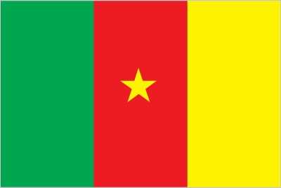
Flag
Description: Three equal vertical bands of green (left side), red, and yellow, with a small five-pointed yellow star centered in the red band
Meaning: Red stands for unity; yellow for the sun, happiness, and the northern savannahs; green for hope and the southern forests; the star is called the "star of unity;" the vertical tricolor design is similar to the French flag
History: Uses the colors of the Pan-African movement
Meaning: Red stands for unity; yellow for the sun, happiness, and the northern savannahs; green for hope and the southern forests; the star is called the "star of unity;" the vertical tricolor design is similar to the French flag
History: Uses the colors of the Pan-African movement
Independence
1 January 1960 (from French-administered UN trusteeship)
Judicial branch
Highest court(s): Supreme Court of Cameroon (consists of 9 titular and 6 surrogate judges and organized into judicial, administrative, and audit chambers); Constitutional Council (consists of 11 members)
Judge selection and term of office: Supreme Court judges appointed by the president with the advice of the Higher Judicial Council of Cameroon, a body chaired by the president and includes the minister of justice, selected magistrates, and representatives of the National Assembly; judge term NA; Constitutional Council members appointed by the president for renewable 6-year terms
Subordinate courts: Parliamentary Court of Justice (jurisdiction limited to cases involving the president and prime minister); appellate and first instance courts; circuit and magistrates' courts
Legal system
mixed system of English common law, French civil law, and customary law
Legislative branch
Legislature name: Parlement - Parliament
Legislative structure: Bicameral
Legislative structure: Bicameral
International organization participation
ACP, AfDB, AU, BDEAC, C, CEMAC, EITI (compliant country), FAO, FZ, G-77, IAEA, IBRD, ICAO, ICRM, IDA, IDB, IFAD, IFC, IFRCS, IHO, ILO, IMF, IMO, IMSO, Interpol, IOC, IOM, IPU, ISO, ITSO, ITU, ITUC (NGOs), LCBC, MIGA, MNJTF, MONUSCO, NAM, OIC, OIF, OPCW, PCA, UN, UNCTAD, UNESCO, UNHRC, UNIDO, UNMISS, UNWTO, UPU, WCO, WFTU (NGOs), WHO, WIPO, WMO, WTO
National holiday
State Unification Day (National Day), 20 May (1972)
Political parties
Alliance for Democracy and Development
Cameroon People's Democratic Movement or CPDM
Cameroon People's Party or CPP
Cameroon Renaissance Movement or MRC
Cameroonian Democratic Union or UDC
Cameroonian Party for National Reconciliation or PCRN
Front for the National Salvation of Cameroon or FSNC
Movement for the Defense of the Republic or MDR
Movement for the Liberation and Development of Cameroon or MLDC
National Union for Democracy and Progress or UNDP
Progressive Movement or MP
Social Democratic Front or SDF
Union of Peoples of Cameroon or UPC
Union of Socialist Movements
Suffrage
20 years of age; universal
Government type
presidential republic
Country name
Conventional long form: Republic of Cameroon
Conventional short form: Cameroon
Local long form: République du Cameroun (French)/Republic of Cameroon (English)
Local short form: Cameroun/Cameroon
Former: Kamerun, French Cameroon, British Cameroon, Federal Republic of Cameroon, United Republic of Cameroon
Etymology: In the 16th century, Portuguese explorers named an estuary near the mouth of the Wouri River the Rio dos Camaroes (River of Prawns) after the abundant shrimp in the water; the name Camaroes evolved into "Cameroon"
Diplomatic representation in the US
Chief of mission: Ambassador Henri ETOUNDI ESSOMBA (since 27 June 2016)
Chancery: 2349 Massachusetts Avenue NW, Washington, DC 20008
Telephone: [1] (202) 265-8790
FAX: [1] (202) 387-3826
Email address and website:
Mail@cameroonembassyusa
Cameroon Embassy in Washington DC, USA (cameroonembassyusa.org)
Chancery: 2349 Massachusetts Avenue NW, Washington, DC 20008
Telephone: [1] (202) 265-8790
FAX: [1] (202) 387-3826
Email address and website:
Mail@cameroonembassyusa
Cameroon Embassy in Washington DC, USA (cameroonembassyusa.org)
National anthem(s)
Title: "O Cameroun, Berceau de Nos Ancêtres" (O Cameroon, Cradle of Our Forefathers)
Lyrics/music: Rene Djam AFAME, Samuel Minkio BAMBA, Moise Nyatte NKO'O [French], Benard Nsokika FONLON [English]/Rene Djam AFAME
History: Adopted 1957; lyrics were changed slightly to the current version in 1978
Lyrics/music: Rene Djam AFAME, Samuel Minkio BAMBA, Moise Nyatte NKO'O [French], Benard Nsokika FONLON [English]/Rene Djam AFAME
History: Adopted 1957; lyrics were changed slightly to the current version in 1978
International law organization participation
accepts compulsory ICJ jurisdiction; non-party state to the ICCt
National symbol(s)
lion
Citizenship
Citizenship by birth: No
Citizenship by descent only: At least one parent must be a citizen of Cameroon
Dual citizenship recognized: No
Residency requirement for naturalization: 5 years
Citizenship by descent only: At least one parent must be a citizen of Cameroon
Dual citizenship recognized: No
Residency requirement for naturalization: 5 years
National heritage
Total World Heritage Sites: 3 (two natural and one cultural)
Selected World Heritage Site locales: Dja Faunal Reserve (n); Sangha Trinational Forest (n); Diy-Gid-Biy Cultural Landscape of the Mandara Mountains (c)
Selected World Heritage Site locales: Dja Faunal Reserve (n); Sangha Trinational Forest (n); Diy-Gid-Biy Cultural Landscape of the Mandara Mountains (c)
National color(s)
green, red, yellow
Household income or consumption by percentage share
Lowest 10%: 2.1% (2021 est.)
Highest 10%: 31.1% (2021 est.)
note: % share of income accruing to lowest and highest 10% of population
Highest 10%: 31.1% (2021 est.)
note: % share of income accruing to lowest and highest 10% of population
Exports - commodities
crude petroleum, natural gas, gold, cocoa beans, wood (2023)
note: top five export commodities based on value in dollars
note: top five export commodities based on value in dollars
Exports - partners
Netherlands 21%, France 14%, UAE 13%, India 9%, China 8% (2023)
note: top five export partners based on percentage share of exports
note: top five export partners based on percentage share of exports
Agricultural products
cassava, plantains, oil palm fruit, maize, taro, tomatoes, sorghum, sugarcane, bananas, vegetables (2023)
note: top ten agricultural products based on tonnage
note: top ten agricultural products based on tonnage
Budget
Revenues: $6.385 billion (2021 est.)
Expenditures: $7.624 billion (2021 est.)
note: central government revenues and expenses (excluding grants/extrabudgetary units/social security funds) converted to US dollars at average official exchange rate for year indicated
Expenditures: $7.624 billion (2021 est.)
note: central government revenues and expenses (excluding grants/extrabudgetary units/social security funds) converted to US dollars at average official exchange rate for year indicated
Imports - commodities
garments, refined petroleum, plastic products, wheat, rice (2023)
note: top five import commodities based on value in dollars
note: top five import commodities based on value in dollars
Exchange rates
Cooperation Financiere en Afrique Centrale francs (XAF) per US dollar -
Exchange rates:
606.345 (2024 est.)
606.57 (2023 est.)
623.76 (2022 est.)
554.531 (2021 est.)
575.586 (2020 est.)
Exchange rates:
606.345 (2024 est.)
606.57 (2023 est.)
623.76 (2022 est.)
554.531 (2021 est.)
575.586 (2020 est.)
Industries
petroleum production and refining, aluminum production, food processing, light consumer goods, textiles, lumber, ship repair
Economic overview
largest CEMAC economy with many natural resources; recent political instability and terrorism reducing economic output; systemic corruption; poor property rights enforcement; increasing poverty in northern regions
GDP (official exchange rate)
$51.327 billion (2024 est.)
note: data in current dollars at official exchange rate
note: data in current dollars at official exchange rate
GDP - composition, by end use
Household consumption: 74.5% (2024 est.)
Government consumption: 10.5% (2024 est.)
Investment in fixed capital: 21.4% (2024 est.)
Investment in inventories: 0% (2024 est.)
Exports of goods and services: 14.7% (2024 est.)
Imports of goods and services: -21.1% (2024 est.)
note: figures may not total 100% due to rounding or gaps in data collection
Imports - partners
China 43%, France 6%, India 6%, Belgium 4%, UAE 4% (2023)
note: top five import partners based on percentage share of imports
note: top five import partners based on percentage share of imports
Average household expenditures
On food: 45.8% of household expenditures (2023 est.)
On alcohol and tobacco: 2.9% of household expenditures (2023 est.)
On alcohol and tobacco: 2.9% of household expenditures (2023 est.)
Remittances
1.6% of GDP (2023 est.)
1.3% of GDP (2022 est.)
1% of GDP (2021 est.)
note: personal transfers and compensation between resident and non-resident individuals/households/entities
1.3% of GDP (2022 est.)
1% of GDP (2021 est.)
note: personal transfers and compensation between resident and non-resident individuals/households/entities
Labor force
11.119 million (2024 est.)
note: number of people ages 15 or older who are employed or seeking work
note: number of people ages 15 or older who are employed or seeking work
Debt - external
$11.112 billion (2023 est.)
note: present value of external debt in current US dollars
note: present value of external debt in current US dollars
Reserves of foreign exchange and gold
$4.882 billion (2023 est.)
$5.133 billion (2022 est.)
$4.3 billion (2021 est.)
note: holdings of gold (year-end prices)/foreign exchange/special drawing rights in current dollars
$5.133 billion (2022 est.)
$4.3 billion (2021 est.)
note: holdings of gold (year-end prices)/foreign exchange/special drawing rights in current dollars
Unemployment rate
3.6% (2024 est.)
3.7% (2023 est.)
3.7% (2022 est.)
note: % of labor force seeking employment
3.7% (2023 est.)
3.7% (2022 est.)
note: % of labor force seeking employment
Taxes and other revenues
11.3% (of GDP) (2021 est.)
note: central government tax revenue as a % of GDP
note: central government tax revenue as a % of GDP
Real GDP (purchasing power parity)
$143.264 billion (2024 est.)
$138.191 billion (2023 est.)
$133.843 billion (2022 est.)
note: data in 2021 dollars
$138.191 billion (2023 est.)
$133.843 billion (2022 est.)
note: data in 2021 dollars
Inflation rate (consumer prices)
4.5% (2024 est.)
7.4% (2023 est.)
6.2% (2022 est.)
note: annual % change based on consumer prices
7.4% (2023 est.)
6.2% (2022 est.)
note: annual % change based on consumer prices
Current account balance
-$2.019 billion (2023 est.)
-$1.505 billion (2022 est.)
-$1.794 billion (2021 est.)
note: balance of payments - net trade and primary/secondary income in current dollars
-$1.505 billion (2022 est.)
-$1.794 billion (2021 est.)
note: balance of payments - net trade and primary/secondary income in current dollars
Real GDP per capita
$4,900 (2024 est.)
$4,900 (2023 est.)
$4,800 (2022 est.)
note: data in 2021 dollars
$4,900 (2023 est.)
$4,800 (2022 est.)
note: data in 2021 dollars
Imports
$10.294 billion (2023 est.)
$9.759 billion (2022 est.)
$9.025 billion (2021 est.)
note: balance of payments - imports of goods and services in current dollars
$9.759 billion (2022 est.)
$9.025 billion (2021 est.)
note: balance of payments - imports of goods and services in current dollars
Exports
$8.353 billion (2023 est.)
$8.641 billion (2022 est.)
$7.447 billion (2021 est.)
note: balance of payments - exports of goods and services in current dollars
$8.641 billion (2022 est.)
$7.447 billion (2021 est.)
note: balance of payments - exports of goods and services in current dollars
Real GDP growth rate
3.7% (2024 est.)
3.2% (2023 est.)
3.7% (2022 est.)
note: annual GDP % growth based on constant local currency
3.2% (2023 est.)
3.7% (2022 est.)
note: annual GDP % growth based on constant local currency
Industrial production growth rate
1.9% (2024 est.)
note: annual % change in industrial value added based on constant local currency
note: annual % change in industrial value added based on constant local currency
GDP - composition, by sector of origin
Agriculture: 17.4% (2024 est.)
Industry: 25.6% (2024 est.)
Services: 49.9% (2024 est.)
note: figures may not total 100% due to non-allocated consumption not captured in sector-reported data
Industry: 25.6% (2024 est.)
Services: 49.9% (2024 est.)
note: figures may not total 100% due to non-allocated consumption not captured in sector-reported data
Electricity access
Electrification - total population: 71% (2022 est.)
Electrification - urban areas: 94%
Electrification - rural areas: 25%
Electrification - urban areas: 94%
Electrification - rural areas: 25%
Coal
Imports: 300 metric tons (2023 est.)
Electricity generation sources
Fossil fuels: 36.1% of total installed capacity (2023 est.)
Solar: 0.3% of total installed capacity (2023 est.)
Hydroelectricity: 63.1% of total installed capacity (2023 est.)
Biomass and waste: 0.5% of total installed capacity (2023 est.)
Solar: 0.3% of total installed capacity (2023 est.)
Hydroelectricity: 63.1% of total installed capacity (2023 est.)
Biomass and waste: 0.5% of total installed capacity (2023 est.)
Natural gas
Production: 2.356 billion cubic meters (2023 est.)
Consumption: 534.691 million cubic meters (2023 est.)
Exports: 1.821 billion cubic meters (2023 est.)
Proven reserves: 135.071 billion cubic meters (2021 est.)
Consumption: 534.691 million cubic meters (2023 est.)
Exports: 1.821 billion cubic meters (2023 est.)
Proven reserves: 135.071 billion cubic meters (2021 est.)
Petroleum
Total petroleum production: 64,000 bbl/day (2023 est.)
Refined petroleum consumption: 41,000 bbl/day (2023 est.)
Crude oil estimated reserves: 200 million barrels (2021 est.)
Refined petroleum consumption: 41,000 bbl/day (2023 est.)
Crude oil estimated reserves: 200 million barrels (2021 est.)
Electricity
Installed generating capacity: 1.798 million kW (2023 est.)
Consumption: 6.161 billion kWh (2023 est.)
Imports: 60 million kWh (2023 est.)
Transmission/distribution losses: 2.238 billion kWh (2023 est.)
Consumption: 6.161 billion kWh (2023 est.)
Imports: 60 million kWh (2023 est.)
Transmission/distribution losses: 2.238 billion kWh (2023 est.)
Internet users
Percent of population: 42% (2023 est.)
Internet country code
.cm
Broadcast media
government maintains tight control over broadcast media; state-owned Cameroon Radio Television (CRTV), with both TV and radio broadcasts, was the only officially recognized and fully licensed broadcaster until 2007, when the government issued licenses to 2 private TV broadcasters and 1 private radio broadcaster; about 70 privately owned, unlicensed radio stations operate under “administrative tolerance,” meaning the stations could be subject to closure at any time (2023)
Telephones - mobile cellular
Total subscriptions: 26.2 million (2023 est.)
Subscriptions per 100 inhabitants: 83 (2022 est.)
Subscriptions per 100 inhabitants: 83 (2022 est.)
Broadband - fixed subscriptions
Total: 603,000 (2022 est.)
Subscriptions per 100 inhabitants: 2 (2022 est.)
Subscriptions per 100 inhabitants: 2 (2022 est.)
Telephones - fixed lines
Total subscriptions: 896,000 (2022 est.)
Subscriptions per 100 inhabitants: 3 (2022 est.)
Subscriptions per 100 inhabitants: 3 (2022 est.)
Railways
Total: 987 km (2014)
Narrow gauge: 987 km (2014) 1.000-m gauge
Note: Railway connections generally efficient but limited; rail lines connect major cities of Douala, Yaounde, Ngaoundere, and Garoua; passenger and freight service provided by CAMRAIL
Narrow gauge: 987 km (2014) 1.000-m gauge
Note: Railway connections generally efficient but limited; rail lines connect major cities of Douala, Yaounde, Ngaoundere, and Garoua; passenger and freight service provided by CAMRAIL
Civil aircraft registration country code prefix
TJ
Airports
37 (2025)
Merchant marine
Total: 198 (2023)
By type: Bulk carrier 2, general cargo 91, oil tanker 42, other 63
By type: Bulk carrier 2, general cargo 91, oil tanker 42, other 63
Heliports
1 (2025)
Military expenditures
1% of GDP (2024 est.)
1% of GDP (2023 est.)
1% of GDP (2022 est.)
1% of GDP (2021 est.)
1% of GDP (2020 est.)
1% of GDP (2023 est.)
1% of GDP (2022 est.)
1% of GDP (2021 est.)
1% of GDP (2020 est.)
Military and security forces
Cameroon Armed Forces (Forces Armees Camerounaises, FAC): Army, Cameroon Navy (includes naval infantry or fusiliers marin), Air Force, National Gendarmerie, National Firefighting Corps
General Delegation for National Security (Délégation Générale à la Sûreté Nationale or DGSN): Cameroon Police (2025)
Note 1: The Army includes the Rapid Intervention Brigade (Brigade d’Intervention Rapide or BIR), which maintains its own command and control structure and reports directly to the Chief of Defense staff and the Presidency; the BIR includes airborne/airmobile, amphibious, armored reconnaissance, artillery, and counterterrorism forces, as well as support elements, such as intelligence
Note 2: The Cameroon Police and the National Gendarmerie are responsible for internal security; the Gendarmerie conducts administrative, criminal, and military investigative functions; other missions include customs, air and maritime surveillance, and road traffic control; in times of conflict, it participates in internal defense
Military - note
the Cameroon Armed Forces (FAC) are responsible for defending the country's territorial integrity, providing humanitarian assistance, supporting regional peacekeeping operations, and contributing to internal security; key areas of focus are the threat from the terrorist groups Boko Haram and ISIS-West Africa along its frontiers with Nigeria and Chad (Far North region) and, since 2016, an insurgency from armed Anglophone separatist groups in the North-West and South-West regions; in addition, the FAC often deploys ground units to the border region with the Central African Republic to counter intrusions from armed militias and bandits; the Navy’s missions include protecting Cameroon’s oil installations, combatting crime and piracy in the Gulf of Guinea, and patrolling the country’s lakes and rivers; the FAC's small Air Force supports both the ground and naval forces (2025)
Military and security service personnel strengths
estimated 40-50,000 active FAC, including the Gendarmerie (2025)
Military deployments
750 (plus about 400 police) Central African Republic (MINUSCA) (2025)
Note: Cameroon has committed approximately 2,000-2,500 troops to the Multinational Joint Task Force (MNJTF) against Boko Haram and other terrorist groups operating in the general area of the Lake Chad Basin and along Nigeria's northeast border; national MNJTF troop contingents are deployed within their own country territories, although cross‐border operations occur occasionally
Note: Cameroon has committed approximately 2,000-2,500 troops to the Multinational Joint Task Force (MNJTF) against Boko Haram and other terrorist groups operating in the general area of the Lake Chad Basin and along Nigeria's northeast border; national MNJTF troop contingents are deployed within their own country territories, although cross‐border operations occur occasionally
Military equipment inventories and acquisitions
the FAC inventory is comprised of armaments from a variety of countries, including China, Israel, Russia/former Soviet Union, South Africa, the US, and some Western European countries, particularly France (2025)
Military service age and obligation
18-23 years of age for voluntary military service for men and women (18-28 for medical services); no conscription; service obligation 4 years (2025)
Refugees and internally displaced persons
Refugees: 443,740 (2024 est.)
IDPs: 1,058,405 (2024 est.)
IDPs: 1,058,405 (2024 est.)
Terrorist group(s)
Terrorist group(s): Boko Haram; Islamic State of Iraq and ash-Sham – West Africa
Note: Details about the history, aims, leadership, organization, areas of operation, tactics, targets, weapons, size, and sources of support of the group(s) appear(s) in the Terrorism reference guide
Note: Details about the history, aims, leadership, organization, areas of operation, tactics, targets, weapons, size, and sources of support of the group(s) appear(s) in the Terrorism reference guide
Ports
Total ports: 7 (2024)
Large: 0
Medium: 1
Small: 0
Very small: 5
Size unknown: 1
Ports with oil terminals: 5
Key ports: Douala, Ebome Marine Terminal, Kole Oil Terminal, Kome Kribi 1 Marine Terminal, Kribi Deep Sea Port, Limboh Terminal, Moudi Marine Terminal
Large: 0
Medium: 1
Small: 0
Very small: 5
Size unknown: 1
Ports with oil terminals: 5
Key ports: Douala, Ebome Marine Terminal, Kole Oil Terminal, Kome Kribi 1 Marine Terminal, Kribi Deep Sea Port, Limboh Terminal, Moudi Marine Terminal
Legislative branch - lower chamber
Chamber name: National Assembly (Assemblée nationale - National Assembly)
Number of seats: 180 (all directly elected)
Electoral system: Proportional representation
Scope of elections: Full renewal
Term in office: 5 years
Most recent election date: 3/12/2023
Parties elected and seats per party: Cameroon People's Democratic Movement (RDPC/CPDM) (152); Other (28)
Percentage of women in chamber: 33.9%
Expected date of next election: February 2026
Legislative branch - upper chamber
Chamber name: Senate (Sénat - Senate)
Number of seats: 100 (70 indirectly elected; 30 appointed)
Scope of elections: Full renewal
Term in office: 5 years
Most recent election date: 2/9/2020 to 3/22/2020
Percentage of women in chamber: 33%
Expected date of next election: March 2027
Number of seats: 100 (70 indirectly elected; 30 appointed)
Scope of elections: Full renewal
Term in office: 5 years
Most recent election date: 2/9/2020 to 3/22/2020
Percentage of women in chamber: 33%
Expected date of next election: March 2027
Methane emissions
Energy: 293.3 kt (2022-2024 est.)
Agriculture: 278.2 kt (2019-2021 est.)
Waste: 166.4 kt (2019-2021 est.)
Other: 24 kt (2019-2021 est.)
Agriculture: 278.2 kt (2019-2021 est.)
Waste: 166.4 kt (2019-2021 est.)
Other: 24 kt (2019-2021 est.)
Gini Index coefficient - distribution of family income
42.2 (2021 est.)
note: index (0-100) of income distribution; higher values represent greater inequality
note: index (0-100) of income distribution; higher values represent greater inequality